You are here: Home > Network List > AZ - ANZA Regional Network Stations List
> Station MONP2 Monument Peak TA Vault, Anza, CA, USA > Earthquake Result Viewer
MONP2 Monument Peak TA Vault, Anza, CA, USA - Earthquake Result Viewer

| Earthquake location: |
South Of Fiji Islands |
| Earthquake latitude/longitude: |
-23.7/-176.9 |
| Earthquake time(UTC): |
2017/09/26 (269) 04:20:00 GMT |
| Earthquake Depth: |
98 km |
| Earthquake Magnitude: |
6.4 mww |
| Earthquake Catalog/Contributor: |
NEIC PDE/us |
|
| Network: |
AZ ANZA Regional Network |
| Station: |
MONP2 Monument Peak TA Vault, Anza, CA, USA |
| Lat/Lon: |
32.89 N/116.42 W |
| Elevation: |
1000 m |
|
| Distance: |
80.6 deg |
| Az: |
47.933 deg |
| Baz: |
233.971 deg |
| Ray Param: |
0.047957975 |
| Estimated Moho Depth: |
30.25 km |
| Estimated Crust Vp/Vs: |
1.78 |
| Assumed Crust Vp: |
6.264 km/s |
| Estimated Crust Vs: |
3.519 km/s |
| Estimated Crust Poisson's Ratio: |
0.27 |
|
| Radial Match: |
85.49412 % |
| Radial Bump: |
341 |
| Transverse Match: |
69.58657 % |
| Transverse Bump: |
400 |
| SOD ConfigId: |
13570011 |
| Insert Time: |
2019-04-28 21:25:16.172 +0000 |
| GWidth: |
2.5 |
| Max Bumps: |
400 |
| Tol: |
0.001 |
|
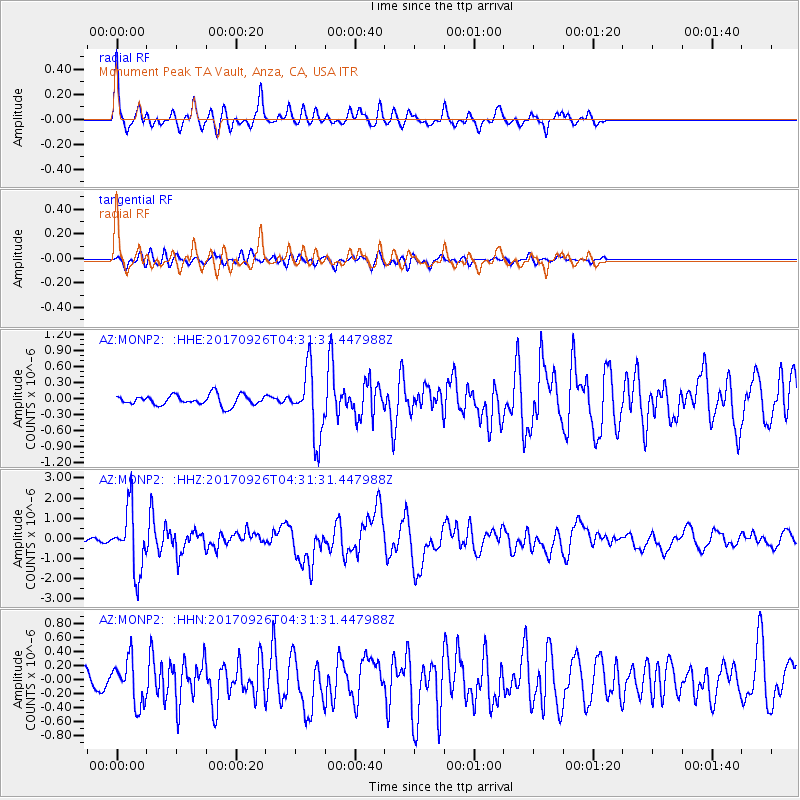
Signal To Noise
| Channel | StoN | STA | LTA |
| AZ:MONP2: :HHZ:20170926T04:31:31.447988Z | 13.773129 | 1.5319764E-6 | 1.11229355E-7 |
| AZ:MONP2: :HHN:20170926T04:31:31.447988Z | 2.6295347 | 3.1459996E-7 | 1.1964092E-7 |
| AZ:MONP2: :HHE:20170926T04:31:31.447988Z | 6.3205285 | 6.133913E-7 | 9.7047476E-8 |
| Arrivals |
| Ps | 3.9 SECOND |
| PpPs | 13 SECOND |
| PsPs/PpSs | 17 SECOND |


