You are here: Home > Network List > CC - Cascade Chain Volcano Monitoring Stations List
> Station JRO Johnston Ridge Observatory > Earthquake Result Viewer
JRO Johnston Ridge Observatory - Earthquake Result Viewer
| Earthquake location: |
South Of Fiji Islands |
| Earthquake latitude/longitude: |
-23.7/-176.9 |
| Earthquake time(UTC): |
2017/09/26 (269) 04:20:00 GMT |
| Earthquake Depth: |
98 km |
| Earthquake Magnitude: |
6.4 mww |
| Earthquake Catalog/Contributor: |
NEIC PDE/us |
|
| Network: |
CC Cascade Chain Volcano Monitoring |
| Station: |
JRO Johnston Ridge Observatory |
| Lat/Lon: |
46.28 N/122.22 W |
| Elevation: |
1280 m |
|
| Distance: |
85.5 deg |
| Az: |
34.611 deg |
| Baz: |
228.639 deg |
| Ray Param: |
0.04454099 |
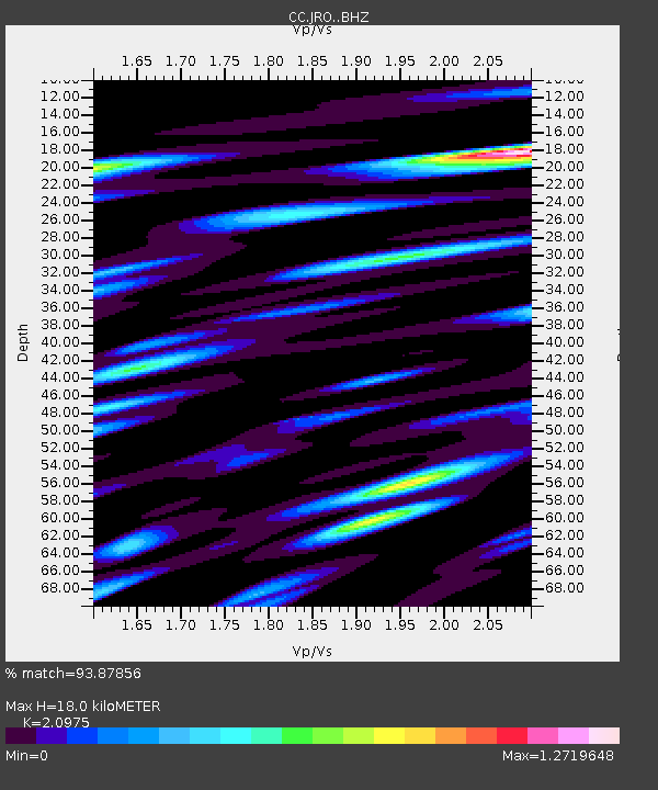
| Estimated Moho Depth: |
18.0 km |
| Estimated Crust Vp/Vs: |
2.10 |
| Assumed Crust Vp: |
6.566 km/s |
| Estimated Crust Vs: |
3.13 km/s |
| Estimated Crust Poisson's Ratio: |
0.35 |
|
| Radial Match: |
93.87856 % |
| Radial Bump: |
400 |
| Transverse Match: |
84.73458 % |
| Transverse Bump: |
400 |
| SOD ConfigId: |
13570011 |
| Insert Time: |
2019-04-28 21:26:22.048 +0000 |
| GWidth: |
2.5 |
| Max Bumps: |
400 |
| Tol: |
0.001 |
|

Signal To Noise
| Channel | StoN | STA | LTA |
| CC:JRO: :BHZ:20170926T04:31:56.424978Z | 19.236067 | 1.9677686E-6 | 1.02295786E-7 |
| CC:JRO: :BHN:20170926T04:31:56.424978Z | 3.7517798 | 5.1787504E-7 | 1.380345E-7 |
| CC:JRO: :BHE:20170926T04:31:56.424978Z | 5.264587 | 6.16113E-7 | 1.170297E-7 |
| Arrivals |
| Ps | 3.1 SECOND |
| PpPs | 8.3 SECOND |
| PsPs/PpSs | 11 SECOND |


