You are here: Home > Network List > CI - Caltech Regional Seismic Network Stations List
> Station DAN Danby, California, USA > Earthquake Result Viewer
DAN Danby, California, USA - Earthquake Result Viewer
| Earthquake location: |
South Of Fiji Islands |
| Earthquake latitude/longitude: |
-23.7/-176.9 |
| Earthquake time(UTC): |
2017/09/26 (269) 04:20:00 GMT |
| Earthquake Depth: |
98 km |
| Earthquake Magnitude: |
6.4 mww |
| Earthquake Catalog/Contributor: |
NEIC PDE/us |
|
| Network: |
CI Caltech Regional Seismic Network |
| Station: |
DAN Danby, California, USA |
| Lat/Lon: |
34.64 N/115.38 W |
| Elevation: |
398 m |
|
| Distance: |
82.3 deg |
| Az: |
47.019 deg |
| Baz: |
234.411 deg |
| Ray Param: |
0.04676017 |
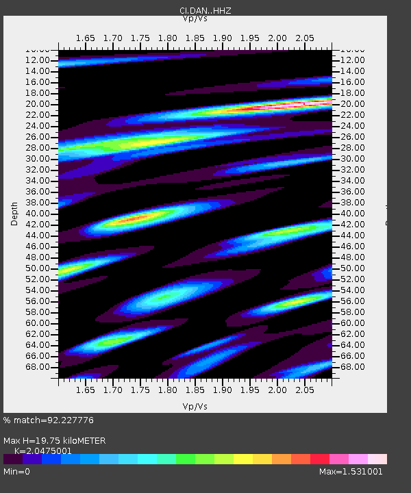
| Estimated Moho Depth: |
19.75 km |
| Estimated Crust Vp/Vs: |
2.05 |
| Assumed Crust Vp: |
6.276 km/s |
| Estimated Crust Vs: |
3.065 km/s |
| Estimated Crust Poisson's Ratio: |
0.34 |
|
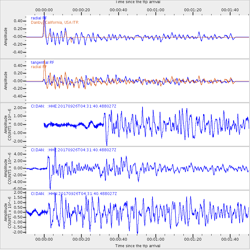
| Radial Match: |
92.227776 % |
| Radial Bump: |
400 |
| Transverse Match: |
86.045815 % |
| Transverse Bump: |
400 |
| SOD ConfigId: |
13570011 |
| Insert Time: |
2019-04-28 21:26:43.025 +0000 |
| GWidth: |
2.5 |
| Max Bumps: |
400 |
| Tol: |
0.001 |
|
Signal To Noise
| Channel | StoN | STA | LTA |
| CI:DAN: :HHZ:20170926T04:31:40.488027Z | 17.651302 | 2.2621118E-6 | 1.2815552E-7 |
| CI:DAN: :HHN:20170926T04:31:40.488027Z | 3.6149106 | 6.1762864E-7 | 1.7085586E-7 |
| CI:DAN: :HHE:20170926T04:31:40.488027Z | 5.948386 | 9.724446E-7 | 1.6348041E-7 |
| Arrivals |
| Ps | 3.4 SECOND |
| PpPs | 9.4 SECOND |
| PsPs/PpSs | 13 SECOND |


