You are here: Home > Network List > TA - USArray Transportable Network (new EarthScope stations) Stations List
> Station U25A Circle Dot Ranch, Maxwell, NM, USA > Earthquake Result Viewer
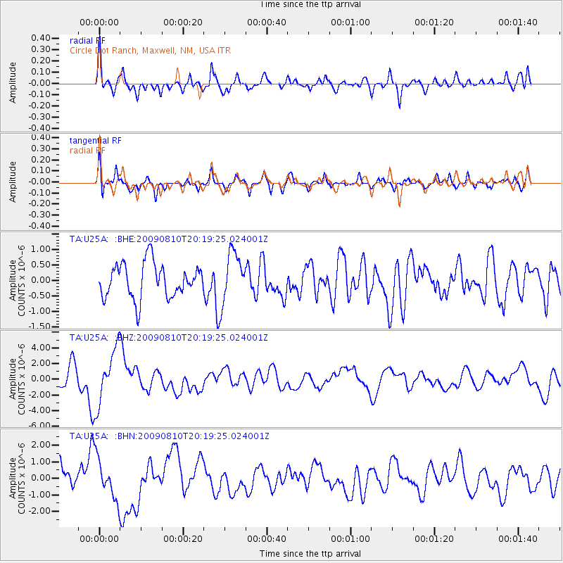
U25A Circle Dot Ranch, Maxwell, NM, USA - Earthquake Result Viewer
*The percent match for this event was below the threshold and hence no stack was calculated.
| Earthquake location: |
Near S. Coast Of Honshu, Japan |
| Earthquake latitude/longitude: |
34.7/138.3 |
| Earthquake time(UTC): |
2009/08/10 (222) 20:07:09 GMT |
| Earthquake Depth: |
40 km |
| Earthquake Magnitude: |
6.1 MB |
| Earthquake Catalog/Contributor: |
WHDF/NEIC |
|
| Network: |
TA USArray Transportable Network (new EarthScope stations) |
| Station: |
U25A Circle Dot Ranch, Maxwell, NM, USA |
| Lat/Lon: |
36.40 N/104.41 W |
| Elevation: |
1845 m |
|
| Distance: |
88.3 deg |
| Az: |
45.814 deg |
| Baz: |
312.952 deg |
| Ray Param: |
$rayparam |
*The percent match for this event was below the threshold and hence was not used in the summary stack. |
|
| Radial Match: |
62.578205 % |
| Radial Bump: |
400 |
| Transverse Match: |
72.964005 % |
| Transverse Bump: |
400 |
| SOD ConfigId: |
2622 |
| Insert Time: |
2010-03-06 04:20:16.367 +0000 |
| GWidth: |
2.5 |
| Max Bumps: |
400 |
| Tol: |
0.001 |
|
Signal To Noise
| Channel | StoN | STA | LTA |
| TA:U25A: :BHZ:20090810T20:19:25.024001Z | 2.2346394 | 3.47637E-6 | 1.5556739E-6 |
| TA:U25A: :BHN:20090810T20:19:25.024001Z | 1.3770924 | 1.1697646E-6 | 8.4944526E-7 |
| TA:U25A: :BHE:20090810T20:19:25.024001Z | 1.4258227 | 7.8333386E-7 | 5.493908E-7 |
| Arrivals |
| Ps | |
| PpPs | |
| PsPs/PpSs | |


