You are here: Home > Network List > NN - Western Great Basin/Eastern Sierra Nevada Stations List
> Station COLR Coleman Ranch, NV portable > Earthquake Result Viewer
COLR Coleman Ranch, NV portable - Earthquake Result Viewer
| Earthquake location: |
South Of Fiji Islands |
| Earthquake latitude/longitude: |
-23.7/-176.9 |
| Earthquake time(UTC): |
2017/09/26 (269) 04:20:00 GMT |
| Earthquake Depth: |
98 km |
| Earthquake Magnitude: |
6.4 mww |
| Earthquake Catalog/Contributor: |
NEIC PDE/us |
|
| Network: |
NN Western Great Basin/Eastern Sierra Nevada |
| Station: |
COLR Coleman Ranch, NV portable |
| Lat/Lon: |
41.96 N/119.79 W |
| Elevation: |
1482 m |
|
| Distance: |
84.0 deg |
| Az: |
39.051 deg |
| Baz: |
230.732 deg |
| Ray Param: |
0.045583133 |
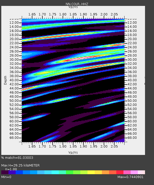
| Estimated Moho Depth: |
29.25 km |
| Estimated Crust Vp/Vs: |
1.88 |
| Assumed Crust Vp: |
6.276 km/s |
| Estimated Crust Vs: |
3.338 km/s |
| Estimated Crust Poisson's Ratio: |
0.30 |
|
| Radial Match: |
81.03003 % |
| Radial Bump: |
400 |
| Transverse Match: |
68.39774 % |
| Transverse Bump: |
400 |
| SOD ConfigId: |
13570011 |
| Insert Time: |
2019-04-28 21:29:00.499 +0000 |
| GWidth: |
2.5 |
| Max Bumps: |
400 |
| Tol: |
0.001 |
|

Signal To Noise
| Channel | StoN | STA | LTA |
| NN:COLR: :HHZ:20170926T04:31:49.119985Z | 16.943325 | 1.5064278E-6 | 8.8909815E-8 |
| NN:COLR: :HHN:20170926T04:31:49.119985Z | 2.3206084 | 3.2341975E-7 | 1.3936851E-7 |
| NN:COLR: :HHE:20170926T04:31:49.119985Z | 3.0943742 | 4.4466387E-7 | 1.4370075E-7 |
| Arrivals |
| Ps | 4.2 SECOND |
| PpPs | 13 SECOND |
| PsPs/PpSs | 17 SECOND |


