You are here: Home > Network List > NN - Western Great Basin/Eastern Sierra Nevada Stations List
> Station KVN Kaiserville, Nevada w84gm > Earthquake Result Viewer
KVN Kaiserville, Nevada w84gm - Earthquake Result Viewer
| Earthquake location: |
South Of Fiji Islands |
| Earthquake latitude/longitude: |
-23.7/-176.9 |
| Earthquake time(UTC): |
2017/09/26 (269) 04:20:00 GMT |
| Earthquake Depth: |
98 km |
| Earthquake Magnitude: |
6.4 mww |
| Earthquake Catalog/Contributor: |
NEIC PDE/us |
|
| Network: |
NN Western Great Basin/Eastern Sierra Nevada |
| Station: |
KVN Kaiserville, Nevada w84gm |
| Lat/Lon: |
39.05 N/118.10 W |
| Elevation: |
1829 m |
|
| Distance: |
83.2 deg |
| Az: |
42.146 deg |
| Baz: |
232.171 deg |
| Ray Param: |
0.04614546 |
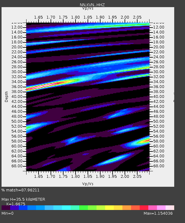
| Estimated Moho Depth: |
35.5 km |
| Estimated Crust Vp/Vs: |
1.67 |
| Assumed Crust Vp: |
6.279 km/s |
| Estimated Crust Vs: |
3.765 km/s |
| Estimated Crust Poisson's Ratio: |
0.22 |
|
| Radial Match: |
87.96211 % |
| Radial Bump: |
400 |
| Transverse Match: |
83.54021 % |
| Transverse Bump: |
400 |
| SOD ConfigId: |
13570011 |
| Insert Time: |
2019-04-28 21:29:02.414 +0000 |
| GWidth: |
2.5 |
| Max Bumps: |
400 |
| Tol: |
0.001 |
|

Signal To Noise
| Channel | StoN | STA | LTA |
| NN:KVN: :HHZ:20170926T04:31:45.03002Z | 13.412169 | 1.2186888E-6 | 9.0864404E-8 |
| NN:KVN: :HHN:20170926T04:31:45.03002Z | 3.6567569 | 2.8218284E-7 | 7.716751E-8 |
| NN:KVN: :HHE:20170926T04:31:45.03002Z | 6.0452447 | 2.6851828E-7 | 4.4418098E-8 |
| Arrivals |
| Ps | 3.9 SECOND |
| PpPs | 15 SECOND |
| PsPs/PpSs | 19 SECOND |


