You are here: Home > Network List > NN - Western Great Basin/Eastern Sierra Nevada Stations List
> Station PNT Pine Nut, Nevada w84 > Earthquake Result Viewer
PNT Pine Nut, Nevada w84 - Earthquake Result Viewer
| Earthquake location: |
South Of Fiji Islands |
| Earthquake latitude/longitude: |
-23.7/-176.9 |
| Earthquake time(UTC): |
2017/09/26 (269) 04:20:00 GMT |
| Earthquake Depth: |
98 km |
| Earthquake Magnitude: |
6.4 mww |
| Earthquake Catalog/Contributor: |
NEIC PDE/us |
|
| Network: |
NN Western Great Basin/Eastern Sierra Nevada |
| Station: |
PNT Pine Nut, Nevada w84 |
| Lat/Lon: |
39.09 N/119.60 W |
| Elevation: |
2076 m |
|
| Distance: |
82.3 deg |
| Az: |
41.385 deg |
| Baz: |
231.134 deg |
| Ray Param: |
0.046765663 |
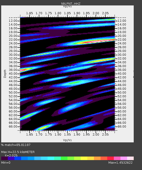
| Estimated Moho Depth: |
22.5 km |
| Estimated Crust Vp/Vs: |
2.03 |
| Assumed Crust Vp: |
6.279 km/s |
| Estimated Crust Vs: |
3.101 km/s |
| Estimated Crust Poisson's Ratio: |
0.34 |
|
| Radial Match: |
85.81187 % |
| Radial Bump: |
400 |
| Transverse Match: |
81.45943 % |
| Transverse Bump: |
400 |
| SOD ConfigId: |
13570011 |
| Insert Time: |
2019-04-28 21:29:11.228 +0000 |
| GWidth: |
2.5 |
| Max Bumps: |
400 |
| Tol: |
0.001 |
|

Signal To Noise
| Channel | StoN | STA | LTA |
| NN:PNT: :HHZ:20170926T04:31:40.450002Z | 11.838766 | 1.6308308E-6 | 1.3775343E-7 |
| NN:PNT: :HHN:20170926T04:31:40.450002Z | 4.7876844 | 3.8165115E-7 | 7.9715186E-8 |
| NN:PNT: :HHE:20170926T04:31:40.450002Z | 9.165431 | 6.5165204E-7 | 7.10989E-8 |
| Arrivals |
| Ps | 3.8 SECOND |
| PpPs | 11 SECOND |
| PsPs/PpSs | 14 SECOND |


