You are here: Home > Network List > NN - Western Great Basin/Eastern Sierra Nevada Stations List
> Station YER Yerington, Nevada w84gm > Earthquake Result Viewer
YER Yerington, Nevada w84gm - Earthquake Result Viewer
| Earthquake location: |
South Of Fiji Islands |
| Earthquake latitude/longitude: |
-23.7/-176.9 |
| Earthquake time(UTC): |
2017/09/26 (269) 04:20:00 GMT |
| Earthquake Depth: |
98 km |
| Earthquake Magnitude: |
6.4 mww |
| Earthquake Catalog/Contributor: |
NEIC PDE/us |
|
| Network: |
NN Western Great Basin/Eastern Sierra Nevada |
| Station: |
YER Yerington, Nevada w84gm |
| Lat/Lon: |
38.99 N/119.24 W |
| Elevation: |
1857 m |
|
| Distance: |
82.5 deg |
| Az: |
41.643 deg |
| Baz: |
231.394 deg |
| Ray Param: |
0.046659693 |
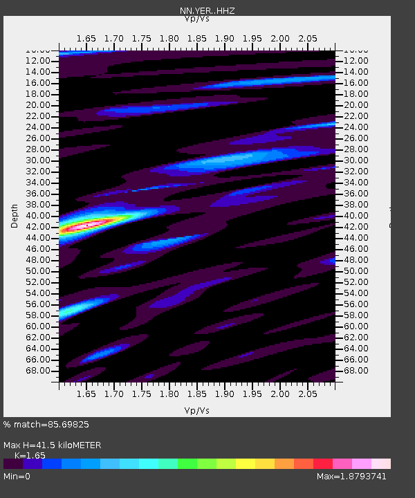
| Estimated Moho Depth: |
41.5 km |
| Estimated Crust Vp/Vs: |
1.65 |
| Assumed Crust Vp: |
6.279 km/s |
| Estimated Crust Vs: |
3.805 km/s |
| Estimated Crust Poisson's Ratio: |
0.21 |
|
| Radial Match: |
85.69825 % |
| Radial Bump: |
400 |
| Transverse Match: |
84.31784 % |
| Transverse Bump: |
400 |
| SOD ConfigId: |
13570011 |
| Insert Time: |
2019-04-28 21:29:20.593 +0000 |
| GWidth: |
2.5 |
| Max Bumps: |
400 |
| Tol: |
0.001 |
|

Signal To Noise
| Channel | StoN | STA | LTA |
| NN:YER: :HHZ:20170926T04:31:41.244985Z | 19.477373 | 1.4854076E-6 | 7.6263234E-8 |
| NN:YER: :HHN:20170926T04:31:41.244985Z | 3.776877 | 3.2798337E-7 | 8.683984E-8 |
| NN:YER: :HHE:20170926T04:31:41.244985Z | 4.632895 | 4.7293088E-7 | 1.0208107E-7 |
| Arrivals |
| Ps | 4.4 SECOND |
| PpPs | 17 SECOND |
| PsPs/PpSs | 21 SECOND |


