You are here: Home > Network List > CI - Caltech Regional Seismic Network Stations List
> Station SMM Simmler, CA, USA > Earthquake Result Viewer
SMM Simmler, CA, USA - Earthquake Result Viewer
| Earthquake location: |
Caribbean Sea |
| Earthquake latitude/longitude: |
19.0/-81.4 |
| Earthquake time(UTC): |
2004/12/14 (349) 23:20:13 GMT |
| Earthquake Depth: |
10 km |
| Earthquake Magnitude: |
6.2 MB, 6.7 MS, 6.8 MW, 6.8 MW |
| Earthquake Catalog/Contributor: |
WHDF/NEIC |
|
| Network: |
CI Caltech Regional Seismic Network |
| Station: |
SMM Simmler, CA, USA |
| Lat/Lon: |
35.31 N/120.00 W |
| Elevation: |
599 m |
|
| Distance: |
37.7 deg |
| Az: |
303.547 deg |
| Baz: |
105.313 deg |
| Ray Param: |
0.075968966 |
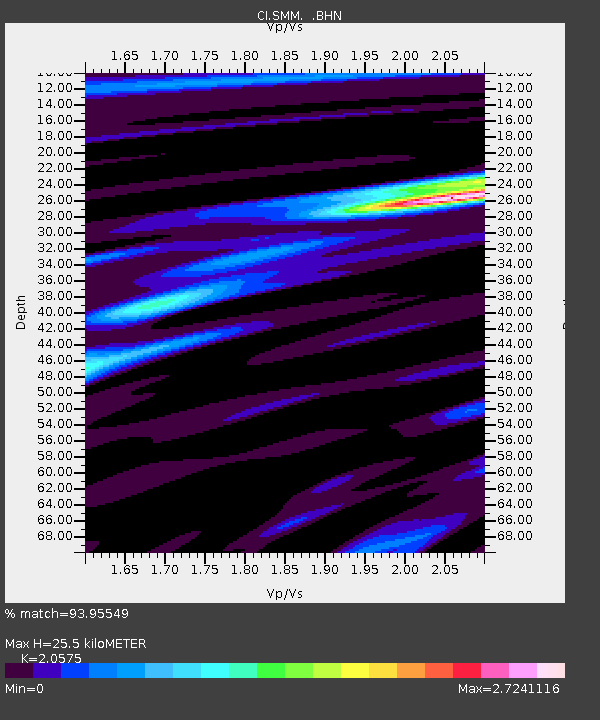
| Estimated Moho Depth: |
25.5 km |
| Estimated Crust Vp/Vs: |
2.06 |
| Assumed Crust Vp: |
6.1 km/s |
| Estimated Crust Vs: |
2.965 km/s |
| Estimated Crust Poisson's Ratio: |
0.35 |
|
| Radial Match: |
93.95549 % |
| Radial Bump: |
339 |
| Transverse Match: |
63.482136 % |
| Transverse Bump: |
400 |
| SOD ConfigId: |
2459 |
| Insert Time: |
2010-02-26 01:29:28.946 +0000 |
| GWidth: |
2.5 |
| Max Bumps: |
400 |
| Tol: |
0.001 |
|
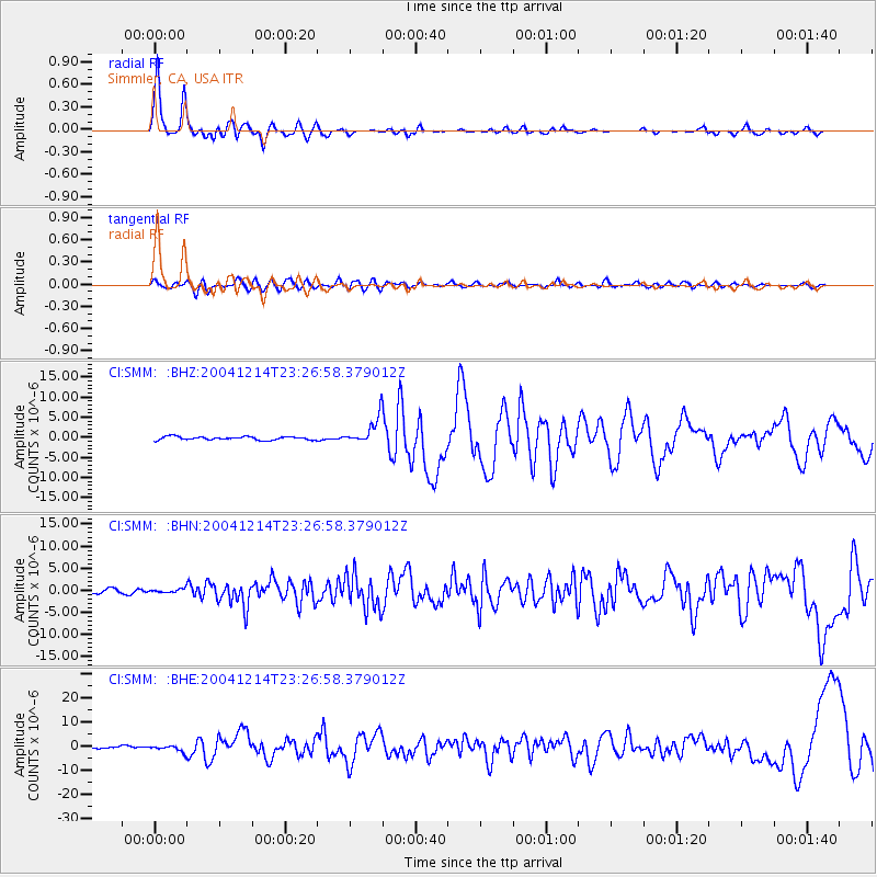
Signal To Noise
| Channel | StoN | STA | LTA |
| CI:SMM: :BHN:20041214T23:26:58.379012Z | 0.45166427 | 4.406823E-7 | 9.756856E-7 |
| CI:SMM: :BHE:20041214T23:26:58.379012Z | 2.4462063 | 1.2957219E-6 | 5.2968625E-7 |
| CI:SMM: :BHZ:20041214T23:26:58.379012Z | 8.017707 | 3.3564472E-6 | 4.1862936E-7 |
| Arrivals |
| Ps | 4.7 SECOND |
| PpPs | 12 SECOND |
| PsPs/PpSs | 17 SECOND |


