You are here: Home > Network List > PB - Plate Boundary Observatory Borehole Seismic Network Stations List
> Station B088 skyoks088bcs2007, Anza, CA, USA > Earthquake Result Viewer
B088 skyoks088bcs2007, Anza, CA, USA - Earthquake Result Viewer
| Earthquake location: |
South Of Fiji Islands |
| Earthquake latitude/longitude: |
-23.7/-176.9 |
| Earthquake time(UTC): |
2017/09/26 (269) 04:20:00 GMT |
| Earthquake Depth: |
98 km |
| Earthquake Magnitude: |
6.4 mww |
| Earthquake Catalog/Contributor: |
NEIC PDE/us |
|
| Network: |
PB Plate Boundary Observatory Borehole Seismic Network |
| Station: |
B088 skyoks088bcs2007, Anza, CA, USA |
| Lat/Lon: |
33.37 N/116.62 W |
| Elevation: |
1404 m |
|
| Distance: |
80.7 deg |
| Az: |
47.439 deg |
| Baz: |
233.783 deg |
| Ray Param: |
0.04785457 |
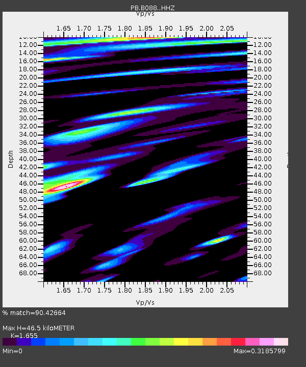
| Estimated Moho Depth: |
46.5 km |
| Estimated Crust Vp/Vs: |
1.65 |
| Assumed Crust Vp: |
6.264 km/s |
| Estimated Crust Vs: |
3.785 km/s |
| Estimated Crust Poisson's Ratio: |
0.21 |
|
| Radial Match: |
90.42664 % |
| Radial Bump: |
400 |
| Transverse Match: |
75.81538 % |
| Transverse Bump: |
400 |
| SOD ConfigId: |
13570011 |
| Insert Time: |
2019-04-28 21:30:10.193 +0000 |
| GWidth: |
2.5 |
| Max Bumps: |
400 |
| Tol: |
0.001 |
|

Signal To Noise
| Channel | StoN | STA | LTA |
| PB:B088: :HHZ:20170926T04:31:32.239004Z | 43.56485 | 9.840957E-8 | 2.2589215E-9 |
| PB:B088: :HH1:20170926T04:31:32.239004Z | 7.842729 | 1.3236185E-8 | 1.6877014E-9 |
| PB:B088: :HH2:20170926T04:31:32.239004Z | 6.1031713 | 1.0562276E-8 | 1.730621E-9 |
| Arrivals |
| Ps | 5.0 SECOND |
| PpPs | 19 SECOND |
| PsPs/PpSs | 24 SECOND |


