You are here: Home > Network List > TA - USArray Transportable Network (new EarthScope stations) Stations List
> Station G31M Satah River, YT, CAN > Earthquake Result Viewer
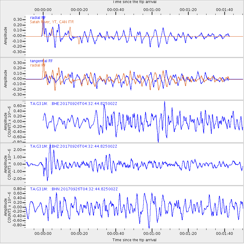
G31M Satah River, YT, CAN - Earthquake Result Viewer
*The percent match for this event was below the threshold and hence no stack was calculated.
| Earthquake location: |
South Of Fiji Islands |
| Earthquake latitude/longitude: |
-23.7/-176.9 |
| Earthquake time(UTC): |
2017/09/26 (269) 04:20:00 GMT |
| Earthquake Depth: |
98 km |
| Earthquake Magnitude: |
6.4 mww |
| Earthquake Catalog/Contributor: |
NEIC PDE/us |
|
| Network: |
TA USArray Transportable Network (new EarthScope stations) |
| Station: |
G31M Satah River, YT, CAN |
| Lat/Lon: |
66.92 N/134.27 W |
| Elevation: |
61 m |
|
| Distance: |
95.8 deg |
| Az: |
15.578 deg |
| Baz: |
218.639 deg |
| Ray Param: |
$rayparam |
*The percent match for this event was below the threshold and hence was not used in the summary stack. |
|
| Radial Match: |
68.72988 % |
| Radial Bump: |
400 |
| Transverse Match: |
63.8495 % |
| Transverse Bump: |
400 |
| SOD ConfigId: |
13570011 |
| Insert Time: |
2019-04-28 21:33:01.125 +0000 |
| GWidth: |
2.5 |
| Max Bumps: |
400 |
| Tol: |
0.001 |
|
Signal To Noise
| Channel | StoN | STA | LTA |
| TA:G31M: :BHZ:20170926T04:32:44.825002Z | 7.4758344 | 1.3218897E-6 | 1.768217E-7 |
| TA:G31M: :BHN:20170926T04:32:44.825002Z | 1.745828 | 2.7570044E-7 | 1.5791959E-7 |
| TA:G31M: :BHE:20170926T04:32:44.825002Z | 2.4105585 | 3.5604987E-7 | 1.477043E-7 |
| Arrivals |
| Ps | |
| PpPs | |
| PsPs/PpSs | |


