You are here: Home > Network List > TA - USArray Transportable Network (new EarthScope stations) Stations List
> Station I26K Coal Creek Mining Camp, AK, USA > Earthquake Result Viewer
I26K Coal Creek Mining Camp, AK, USA - Earthquake Result Viewer
| Earthquake location: |
South Of Fiji Islands |
| Earthquake latitude/longitude: |
-23.7/-176.9 |
| Earthquake time(UTC): |
2017/09/26 (269) 04:20:00 GMT |
| Earthquake Depth: |
98 km |
| Earthquake Magnitude: |
6.4 mww |
| Earthquake Catalog/Contributor: |
NEIC PDE/us |
|
| Network: |
TA USArray Transportable Network (new EarthScope stations) |
| Station: |
I26K Coal Creek Mining Camp, AK, USA |
| Lat/Lon: |
65.31 N/143.15 W |
| Elevation: |
338 m |
|
| Distance: |
92.5 deg |
| Az: |
13.521 deg |
| Baz: |
210.671 deg |
| Ray Param: |
0.0414021 |
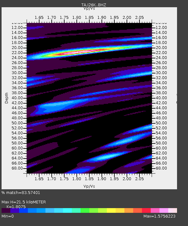
| Estimated Moho Depth: |
21.5 km |
| Estimated Crust Vp/Vs: |
1.81 |
| Assumed Crust Vp: |
6.566 km/s |
| Estimated Crust Vs: |
3.633 km/s |
| Estimated Crust Poisson's Ratio: |
0.28 |
|
| Radial Match: |
83.57401 % |
| Radial Bump: |
400 |
| Transverse Match: |
68.53208 % |
| Transverse Bump: |
400 |
| SOD ConfigId: |
13570011 |
| Insert Time: |
2019-04-28 21:33:15.036 +0000 |
| GWidth: |
2.5 |
| Max Bumps: |
400 |
| Tol: |
0.001 |
|

Signal To Noise
| Channel | StoN | STA | LTA |
| TA:I26K: :BHZ:20170926T04:32:29.400015Z | 15.734737 | 1.4770957E-6 | 9.3874824E-8 |
| TA:I26K: :BHN:20170926T04:32:29.400015Z | 8.138734 | 5.562985E-7 | 6.835197E-8 |
| TA:I26K: :BHE:20170926T04:32:29.400015Z | 3.664647 | 3.21E-7 | 8.75937E-8 |
| Arrivals |
| Ps | 2.7 SECOND |
| PpPs | 9.0 SECOND |
| PsPs/PpSs | 12 SECOND |


