You are here: Home > Network List > TA - USArray Transportable Network (new EarthScope stations) Stations List
> Station K22A Casper, WY, USA > Earthquake Result Viewer
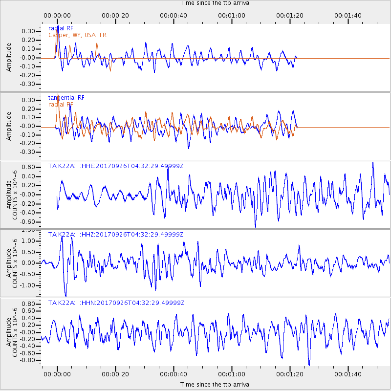
K22A Casper, WY, USA - Earthquake Result Viewer
*The percent match for this event was below the threshold and hence no stack was calculated.
| Earthquake location: |
South Of Fiji Islands |
| Earthquake latitude/longitude: |
-23.7/-176.9 |
| Earthquake time(UTC): |
2017/09/26 (269) 04:20:00 GMT |
| Earthquake Depth: |
98 km |
| Earthquake Magnitude: |
6.4 mww |
| Earthquake Catalog/Contributor: |
NEIC PDE/us |
|
| Network: |
TA USArray Transportable Network (new EarthScope stations) |
| Station: |
K22A Casper, WY, USA |
| Lat/Lon: |
42.65 N/106.52 W |
| Elevation: |
1686 m |
|
| Distance: |
92.5 deg |
| Az: |
44.085 deg |
| Baz: |
239.806 deg |
| Ray Param: |
$rayparam |
*The percent match for this event was below the threshold and hence was not used in the summary stack. |
|
| Radial Match: |
70.25935 % |
| Radial Bump: |
388 |
| Transverse Match: |
66.08581 % |
| Transverse Bump: |
400 |
| SOD ConfigId: |
13570011 |
| Insert Time: |
2019-04-28 21:33:30.547 +0000 |
| GWidth: |
2.5 |
| Max Bumps: |
400 |
| Tol: |
0.001 |
|
Signal To Noise
| Channel | StoN | STA | LTA |
| TA:K22A: :HHZ:20170926T04:32:29.49999Z | 6.1023235 | 7.194334E-7 | 1.1789499E-7 |
| TA:K22A: :HHN:20170926T04:32:29.49999Z | 1.2926855 | 1.9541771E-7 | 1.5117189E-7 |
| TA:K22A: :HHE:20170926T04:32:29.49999Z | 1.7164421 | 2.0932521E-7 | 1.2195297E-7 |
| Arrivals |
| Ps | |
| PpPs | |
| PsPs/PpSs | |


