You are here: Home > Network List > TA - USArray Transportable Network (new EarthScope stations) Stations List
> Station U22A Llaves, NM, USA > Earthquake Result Viewer
U22A Llaves, NM, USA - Earthquake Result Viewer
| Earthquake location: |
Kuril Islands |
| Earthquake latitude/longitude: |
46.0/151.4 |
| Earthquake time(UTC): |
2009/04/18 (108) 19:17:58 GMT |
| Earthquake Depth: |
35 km |
| Earthquake Magnitude: |
6.3 MB, 6.3 MS, 6.6 MW, 6.4 MW |
| Earthquake Catalog/Contributor: |
WHDF/NEIC |
|
| Network: |
TA USArray Transportable Network (new EarthScope stations) |
| Station: |
U22A Llaves, NM, USA |
| Lat/Lon: |
36.38 N/106.85 W |
| Elevation: |
2119 m |
|
| Distance: |
72.0 deg |
| Az: |
56.196 deg |
| Baz: |
314.148 deg |
| Ray Param: |
0.053909544 |
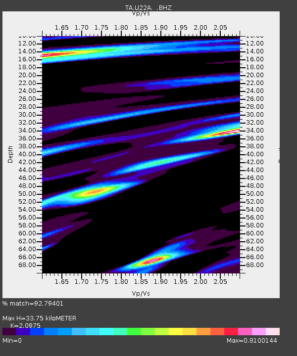
| Estimated Moho Depth: |
33.75 km |
| Estimated Crust Vp/Vs: |
2.10 |
| Assumed Crust Vp: |
6.159 km/s |
| Estimated Crust Vs: |
2.936 km/s |
| Estimated Crust Poisson's Ratio: |
0.35 |
|
| Radial Match: |
92.79401 % |
| Radial Bump: |
396 |
| Transverse Match: |
85.626526 % |
| Transverse Bump: |
400 |
| SOD ConfigId: |
2760 |
| Insert Time: |
2010-03-06 04:22:00.199 +0000 |
| GWidth: |
2.5 |
| Max Bumps: |
400 |
| Tol: |
0.001 |
|

Signal To Noise
| Channel | StoN | STA | LTA |
| TA:U22A: :BHZ:20090418T19:28:48.099006Z | 6.282432 | 1.1795878E-6 | 1.8775974E-7 |
| TA:U22A: :BHN:20090418T19:28:48.099006Z | 1.4185729 | 2.7466467E-7 | 1.9362041E-7 |
| TA:U22A: :BHE:20090418T19:28:48.099006Z | 1.336524 | 3.2986654E-7 | 2.468093E-7 |
| Arrivals |
| Ps | 6.2 SECOND |
| PpPs | 17 SECOND |
| PsPs/PpSs | 23 SECOND |


