You are here: Home > Network List > TA - USArray Transportable Network (new EarthScope stations) Stations List
> Station L18K Granite Mountain, AK, USA > Earthquake Result Viewer
L18K Granite Mountain, AK, USA - Earthquake Result Viewer
| Earthquake location: |
South Of Fiji Islands |
| Earthquake latitude/longitude: |
-23.7/-176.9 |
| Earthquake time(UTC): |
2017/09/26 (269) 04:20:00 GMT |
| Earthquake Depth: |
98 km |
| Earthquake Magnitude: |
6.4 mww |
| Earthquake Catalog/Contributor: |
NEIC PDE/us |
|
| Network: |
TA USArray Transportable Network (new EarthScope stations) |
| Station: |
L18K Granite Mountain, AK, USA |
| Lat/Lon: |
62.22 N/156.69 W |
| Elevation: |
329 m |
|
| Distance: |
87.2 deg |
| Az: |
9.344 deg |
| Baz: |
198.518 deg |
| Ray Param: |
0.04332735 |
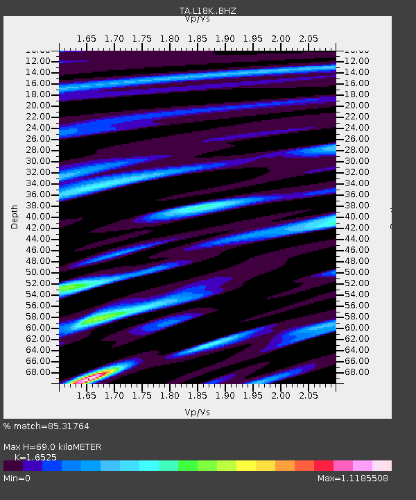
| Estimated Moho Depth: |
69.0 km |
| Estimated Crust Vp/Vs: |
1.65 |
| Assumed Crust Vp: |
6.182 km/s |
| Estimated Crust Vs: |
3.741 km/s |
| Estimated Crust Poisson's Ratio: |
0.21 |
|
| Radial Match: |
85.31764 % |
| Radial Bump: |
400 |
| Transverse Match: |
75.16371 % |
| Transverse Bump: |
400 |
| SOD ConfigId: |
13570011 |
| Insert Time: |
2019-04-28 21:33:35.687 +0000 |
| GWidth: |
2.5 |
| Max Bumps: |
400 |
| Tol: |
0.001 |
|

Signal To Noise
| Channel | StoN | STA | LTA |
| TA:L18K: :BHZ:20170926T04:32:04.700002Z | 21.330196 | 2.3083267E-6 | 1.0821873E-7 |
| TA:L18K: :BHN:20170926T04:32:04.700002Z | 5.4662137 | 4.9183774E-7 | 8.9977775E-8 |
| TA:L18K: :BHE:20170926T04:32:04.700002Z | 2.4939384 | 2.2101393E-7 | 8.8620446E-8 |
| Arrivals |
| Ps | 7.4 SECOND |
| PpPs | 29 SECOND |
| PsPs/PpSs | 36 SECOND |


