You are here: Home > Network List > TA - USArray Transportable Network (new EarthScope stations) Stations List
> Station U22A Llaves, NM, USA > Earthquake Result Viewer
U22A Llaves, NM, USA - Earthquake Result Viewer
| Earthquake location: |
Kuril Islands |
| Earthquake latitude/longitude: |
51.0/157.6 |
| Earthquake time(UTC): |
2008/07/24 (206) 01:43:16 GMT |
| Earthquake Depth: |
27 km |
| Earthquake Magnitude: |
6.0 MB, 6.0 MS, 6.2 MW, 6.2 MW |
| Earthquake Catalog/Contributor: |
WHDF/NEIC |
|
| Network: |
TA USArray Transportable Network (new EarthScope stations) |
| Station: |
U22A Llaves, NM, USA |
| Lat/Lon: |
36.38 N/106.85 W |
| Elevation: |
2119 m |
|
| Distance: |
65.9 deg |
| Az: |
61.618 deg |
| Baz: |
316.423 deg |
| Ray Param: |
0.05791782 |
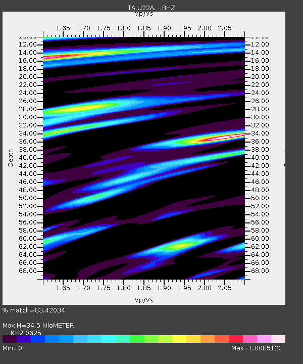
| Estimated Moho Depth: |
34.5 km |
| Estimated Crust Vp/Vs: |
2.06 |
| Assumed Crust Vp: |
6.159 km/s |
| Estimated Crust Vs: |
2.986 km/s |
| Estimated Crust Poisson's Ratio: |
0.35 |
|
| Radial Match: |
83.42034 % |
| Radial Bump: |
362 |
| Transverse Match: |
77.57161 % |
| Transverse Bump: |
341 |
| SOD ConfigId: |
2504 |
| Insert Time: |
2010-03-06 04:22:05.642 +0000 |
| GWidth: |
2.5 |
| Max Bumps: |
400 |
| Tol: |
0.001 |
|

Signal To Noise
| Channel | StoN | STA | LTA |
| TA:U22A: :BHZ:20080724T01:53:28.600022Z | 9.677821 | 1.3180938E-6 | 1.3619737E-7 |
| TA:U22A: :BHN:20080724T01:53:28.600022Z | 1.2809268 | 3.0363168E-7 | 2.3704061E-7 |
| TA:U22A: :BHE:20080724T01:53:28.600022Z | 2.632152 | 4.0589003E-7 | 1.5420463E-7 |
| Arrivals |
| Ps | 6.1 SECOND |
| PpPs | 17 SECOND |
| PsPs/PpSs | 23 SECOND |


