You are here: Home > Network List > TA - USArray Transportable Network (new EarthScope stations) Stations List
> Station M27K Edge Creek, AK, USA > Earthquake Result Viewer
M27K Edge Creek, AK, USA - Earthquake Result Viewer
| Earthquake location: |
South Of Fiji Islands |
| Earthquake latitude/longitude: |
-23.7/-176.9 |
| Earthquake time(UTC): |
2017/09/26 (269) 04:20:00 GMT |
| Earthquake Depth: |
98 km |
| Earthquake Magnitude: |
6.4 mww |
| Earthquake Catalog/Contributor: |
NEIC PDE/us |
|
| Network: |
TA USArray Transportable Network (new EarthScope stations) |
| Station: |
M27K Edge Creek, AK, USA |
| Lat/Lon: |
62.36 N/141.88 W |
| Elevation: |
1536 m |
|
| Distance: |
90.2 deg |
| Az: |
15.54 deg |
| Baz: |
211.768 deg |
| Ray Param: |
0.041669924 |
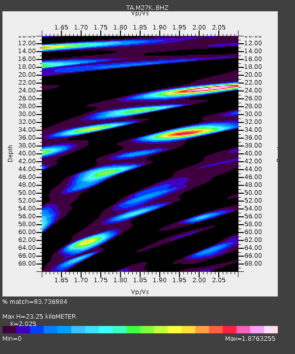
| Estimated Moho Depth: |
23.25 km |
| Estimated Crust Vp/Vs: |
2.03 |
| Assumed Crust Vp: |
6.566 km/s |
| Estimated Crust Vs: |
3.243 km/s |
| Estimated Crust Poisson's Ratio: |
0.34 |
|
| Radial Match: |
93.736984 % |
| Radial Bump: |
400 |
| Transverse Match: |
93.4512 % |
| Transverse Bump: |
400 |
| SOD ConfigId: |
13570011 |
| Insert Time: |
2019-04-28 21:33:50.077 +0000 |
| GWidth: |
2.5 |
| Max Bumps: |
400 |
| Tol: |
0.001 |
|

Signal To Noise
| Channel | StoN | STA | LTA |
| TA:M27K: :BHZ:20170926T04:32:19.075002Z | 40.209736 | 3.511666E-6 | 8.733372E-8 |
| TA:M27K: :BHN:20170926T04:32:19.075002Z | 16.370747 | 1.4435312E-6 | 8.817749E-8 |
| TA:M27K: :BHE:20170926T04:32:19.075002Z | 8.95116 | 8.2319326E-7 | 9.1964985E-8 |
| Arrivals |
| Ps | 3.7 SECOND |
| PpPs | 11 SECOND |
| PsPs/PpSs | 14 SECOND |


