You are here: Home > Network List > TA - USArray Transportable Network (new EarthScope stations) Stations List
> Station N14K Kuskokwak Creek, AK, USA > Earthquake Result Viewer
N14K Kuskokwak Creek, AK, USA - Earthquake Result Viewer
| Earthquake location: |
South Of Fiji Islands |
| Earthquake latitude/longitude: |
-23.7/-176.9 |
| Earthquake time(UTC): |
2017/09/26 (269) 04:20:00 GMT |
| Earthquake Depth: |
98 km |
| Earthquake Magnitude: |
6.4 mww |
| Earthquake Catalog/Contributor: |
NEIC PDE/us |
|
| Network: |
TA USArray Transportable Network (new EarthScope stations) |
| Station: |
N14K Kuskokwak Creek, AK, USA |
| Lat/Lon: |
59.92 N/161.69 W |
| Elevation: |
21 m |
|
| Distance: |
84.3 deg |
| Az: |
7.652 deg |
| Baz: |
194.023 deg |
| Ray Param: |
0.045395482 |
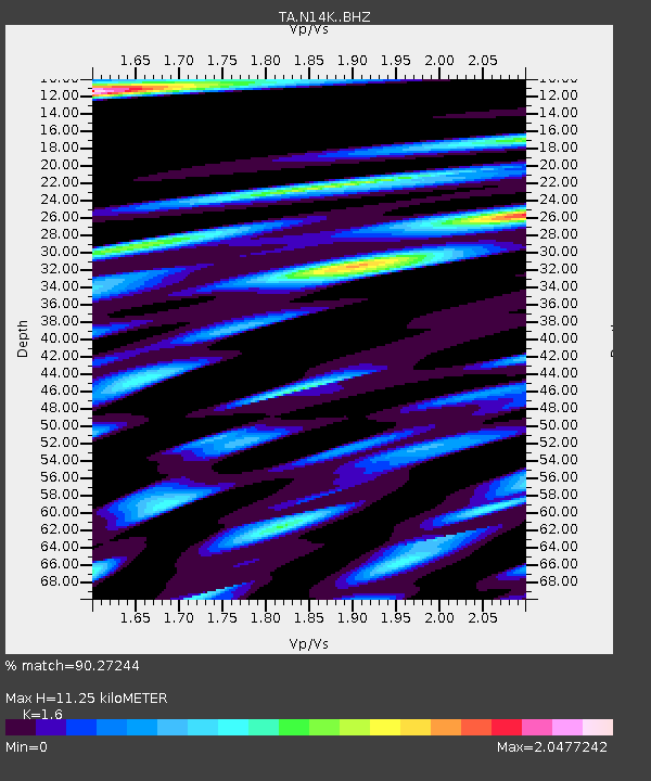
| Estimated Moho Depth: |
11.25 km |
| Estimated Crust Vp/Vs: |
1.60 |
| Assumed Crust Vp: |
6.24 km/s |
| Estimated Crust Vs: |
3.9 km/s |
| Estimated Crust Poisson's Ratio: |
0.18 |
|
| Radial Match: |
90.27244 % |
| Radial Bump: |
400 |
| Transverse Match: |
84.60953 % |
| Transverse Bump: |
400 |
| SOD ConfigId: |
13570011 |
| Insert Time: |
2019-04-28 21:33:54.028 +0000 |
| GWidth: |
2.5 |
| Max Bumps: |
400 |
| Tol: |
0.001 |
|

Signal To Noise
| Channel | StoN | STA | LTA |
| TA:N14K: :BHZ:20170926T04:31:50.450002Z | 28.25972 | 6.2756903E-6 | 2.2207192E-7 |
| TA:N14K: :BHN:20170926T04:31:50.450002Z | 5.1906915 | 2.6235812E-6 | 5.054397E-7 |
| TA:N14K: :BHE:20170926T04:31:50.450002Z | 1.9069277 | 1.3607889E-6 | 7.136028E-7 |
| Arrivals |
| Ps | 1.1 SECOND |
| PpPs | 4.6 SECOND |
| PsPs/PpSs | 5.7 SECOND |


