You are here: Home > Network List > TA - USArray Transportable Network (new EarthScope stations) Stations List
> Station U22A Llaves, NM, USA > Earthquake Result Viewer
U22A Llaves, NM, USA - Earthquake Result Viewer

| Earthquake location: |
Peru-Brazil Border Region |
| Earthquake latitude/longitude: |
-7.6/-74.4 |
| Earthquake time(UTC): |
2008/08/26 (239) 21:00:36 GMT |
| Earthquake Depth: |
154 km |
| Earthquake Magnitude: |
6.0 MB, 6.4 MW, 6.4 MW |
| Earthquake Catalog/Contributor: |
WHDF/NEIC |
|
| Network: |
TA USArray Transportable Network (new EarthScope stations) |
| Station: |
U22A Llaves, NM, USA |
| Lat/Lon: |
36.38 N/106.85 W |
| Elevation: |
2119 m |
|
| Distance: |
53.4 deg |
| Az: |
327.31 deg |
| Baz: |
138.442 deg |
| Ray Param: |
0.065628335 |
| Estimated Moho Depth: |
15.0 km |
| Estimated Crust Vp/Vs: |
2.10 |
| Assumed Crust Vp: |
6.159 km/s |
| Estimated Crust Vs: |
2.936 km/s |
| Estimated Crust Poisson's Ratio: |
0.35 |
|
| Radial Match: |
89.76785 % |
| Radial Bump: |
400 |
| Transverse Match: |
78.64105 % |
| Transverse Bump: |
400 |
| SOD ConfigId: |
2504 |
| Insert Time: |
2010-03-06 04:22:11.381 +0000 |
| GWidth: |
2.5 |
| Max Bumps: |
400 |
| Tol: |
0.001 |
|
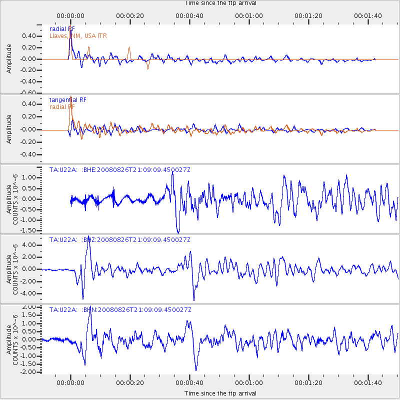
Signal To Noise
| Channel | StoN | STA | LTA |
| TA:U22A: :BHZ:20080826T21:09:09.450027Z | 22.743145 | 1.6718525E-6 | 7.351017E-8 |
| TA:U22A: :BHN:20080826T21:09:09.450027Z | 6.4887977 | 5.77635E-7 | 8.902035E-8 |
| TA:U22A: :BHE:20080826T21:09:09.450027Z | 3.5833247 | 4.9181267E-7 | 1.3725038E-7 |
| Arrivals |
| Ps | 2.8 SECOND |
| PpPs | 7.2 SECOND |
| PsPs/PpSs | 10 SECOND |


