You are here: Home > Network List > TA - USArray Transportable Network (new EarthScope stations) Stations List
> Station U22A Llaves, NM, USA > Earthquake Result Viewer
U22A Llaves, NM, USA - Earthquake Result Viewer
| Earthquake location: |
Virgin Islands |
| Earthquake latitude/longitude: |
19.2/-64.8 |
| Earthquake time(UTC): |
2008/10/11 (285) 10:40:14 GMT |
| Earthquake Depth: |
23 km |
| Earthquake Magnitude: |
6.1 MB, 5.9 MS, 6.1 MW, 6.0 MW |
| Earthquake Catalog/Contributor: |
WHDF/NEIC |
|
| Network: |
TA USArray Transportable Network (new EarthScope stations) |
| Station: |
U22A Llaves, NM, USA |
| Lat/Lon: |
36.38 N/106.85 W |
| Elevation: |
2119 m |
|
| Distance: |
40.6 deg |
| Az: |
303.869 deg |
| Baz: |
103.454 deg |
| Ray Param: |
0.07427866 |
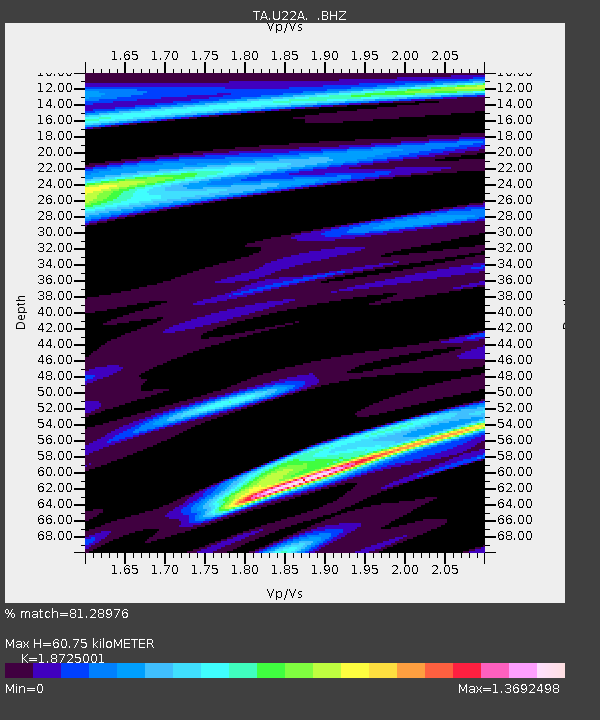
| Estimated Moho Depth: |
60.75 km |
| Estimated Crust Vp/Vs: |
1.87 |
| Assumed Crust Vp: |
6.159 km/s |
| Estimated Crust Vs: |
3.289 km/s |
| Estimated Crust Poisson's Ratio: |
0.30 |
|
| Radial Match: |
81.28976 % |
| Radial Bump: |
400 |
| Transverse Match: |
77.440285 % |
| Transverse Bump: |
400 |
| SOD ConfigId: |
2556 |
| Insert Time: |
2010-03-06 04:22:12.978 +0000 |
| GWidth: |
2.5 |
| Max Bumps: |
400 |
| Tol: |
0.001 |
|
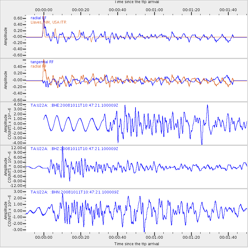
Signal To Noise
| Channel | StoN | STA | LTA |
| TA:U22A: :BHZ:20081011T10:47:21.100009Z | 3.8866858 | 1.8307023E-6 | 4.7101886E-7 |
| TA:U22A: :BHN:20081011T10:47:21.100009Z | 0.6983007 | 5.774633E-7 | 8.26955E-7 |
| TA:U22A: :BHE:20081011T10:47:21.100009Z | 1.0375373 | 1.0849665E-6 | 1.0457132E-6 |
| Arrivals |
| Ps | 9.1 SECOND |
| PpPs | 27 SECOND |
| PsPs/PpSs | 36 SECOND |


