You are here: Home > Network List > TA - USArray Transportable Network (new EarthScope stations) Stations List
> Station P17K Kvichak River, AK, USA > Earthquake Result Viewer
P17K Kvichak River, AK, USA - Earthquake Result Viewer

| Earthquake location: |
South Of Fiji Islands |
| Earthquake latitude/longitude: |
-23.7/-176.9 |
| Earthquake time(UTC): |
2017/09/26 (269) 04:20:00 GMT |
| Earthquake Depth: |
98 km |
| Earthquake Magnitude: |
6.4 mww |
| Earthquake Catalog/Contributor: |
NEIC PDE/us |
|
| Network: |
TA USArray Transportable Network (new EarthScope stations) |
| Station: |
P17K Kvichak River, AK, USA |
| Lat/Lon: |
59.20 N/156.44 W |
| Elevation: |
91 m |
|
| Distance: |
84.3 deg |
| Az: |
10.434 deg |
| Baz: |
198.816 deg |
| Ray Param: |
0.04535648 |
| Estimated Moho Depth: |
69.75 km |
| Estimated Crust Vp/Vs: |
1.69 |
| Assumed Crust Vp: |
6.276 km/s |
| Estimated Crust Vs: |
3.719 km/s |
| Estimated Crust Poisson's Ratio: |
0.23 |
|
| Radial Match: |
82.06594 % |
| Radial Bump: |
400 |
| Transverse Match: |
84.09354 % |
| Transverse Bump: |
400 |
| SOD ConfigId: |
13570011 |
| Insert Time: |
2019-04-28 21:34:12.824 +0000 |
| GWidth: |
2.5 |
| Max Bumps: |
400 |
| Tol: |
0.001 |
|
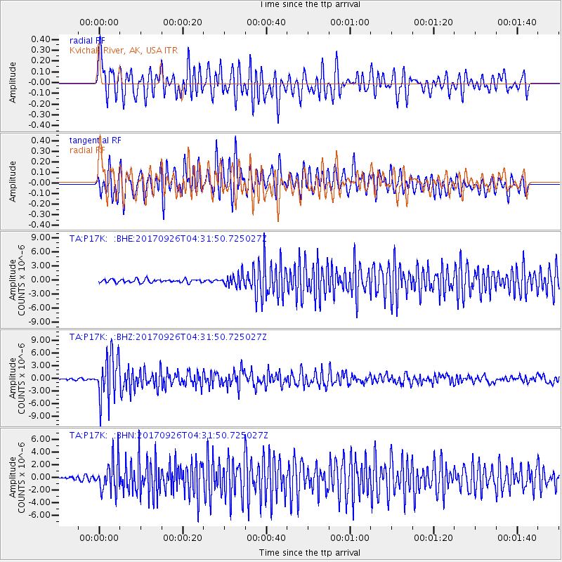
Signal To Noise
| Channel | StoN | STA | LTA |
| TA:P17K: :BHZ:20170926T04:31:50.725027Z | 39.646053 | 5.3443305E-6 | 1.3480108E-7 |
| TA:P17K: :BHN:20170926T04:31:50.725027Z | 8.115274 | 2.5000718E-6 | 3.080699E-7 |
| TA:P17K: :BHE:20170926T04:31:50.725027Z | 3.5177684 | 1.223279E-6 | 3.477429E-7 |
| Arrivals |
| Ps | 7.8 SECOND |
| PpPs | 29 SECOND |
| PsPs/PpSs | 37 SECOND |


