You are here: Home > Network List > TA - USArray Transportable Network (new EarthScope stations) Stations List
> Station S31K Pelican, AK, USA > Earthquake Result Viewer
S31K Pelican, AK, USA - Earthquake Result Viewer
| Earthquake location: |
South Of Fiji Islands |
| Earthquake latitude/longitude: |
-23.7/-176.9 |
| Earthquake time(UTC): |
2017/09/26 (269) 04:20:00 GMT |
| Earthquake Depth: |
98 km |
| Earthquake Magnitude: |
6.4 mww |
| Earthquake Catalog/Contributor: |
NEIC PDE/us |
|
| Network: |
TA USArray Transportable Network (new EarthScope stations) |
| Station: |
S31K Pelican, AK, USA |
| Lat/Lon: |
57.96 N/136.23 W |
| Elevation: |
34 m |
|
| Distance: |
88.2 deg |
| Az: |
20.354 deg |
| Baz: |
216.73 deg |
| Ray Param: |
0.042586192 |
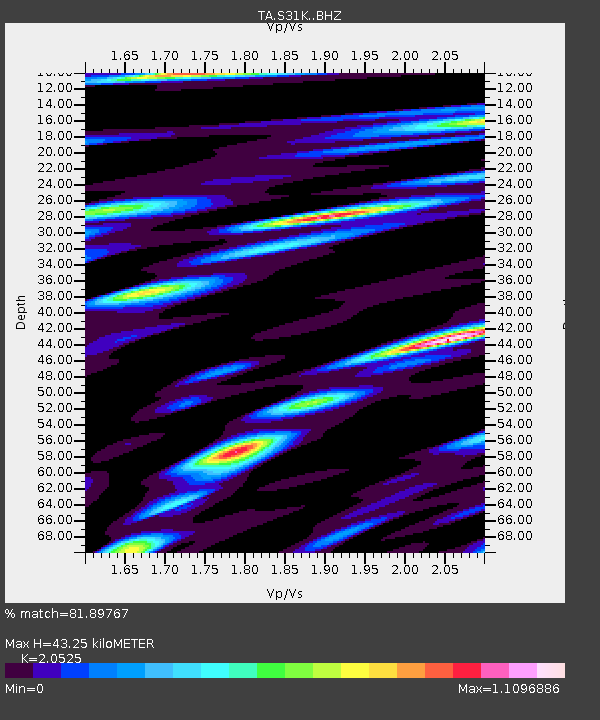
| Estimated Moho Depth: |
43.25 km |
| Estimated Crust Vp/Vs: |
2.05 |
| Assumed Crust Vp: |
6.134 km/s |
| Estimated Crust Vs: |
2.988 km/s |
| Estimated Crust Poisson's Ratio: |
0.34 |
|
| Radial Match: |
81.89767 % |
| Radial Bump: |
400 |
| Transverse Match: |
77.061424 % |
| Transverse Bump: |
400 |
| SOD ConfigId: |
13570011 |
| Insert Time: |
2019-04-28 21:34:33.066 +0000 |
| GWidth: |
2.5 |
| Max Bumps: |
400 |
| Tol: |
0.001 |
|

Signal To Noise
| Channel | StoN | STA | LTA |
| TA:S31K: :BHZ:20170926T04:32:09.49999Z | 9.874803 | 1.953932E-6 | 1.978705E-7 |
| TA:S31K: :BHN:20170926T04:32:09.49999Z | 3.1656418 | 5.2912594E-7 | 1.671465E-7 |
| TA:S31K: :BHE:20170926T04:32:09.49999Z | 2.8719463 | 5.4500697E-7 | 1.8976921E-7 |
| Arrivals |
| Ps | 7.5 SECOND |
| PpPs | 21 SECOND |
| PsPs/PpSs | 29 SECOND |


