You are here: Home > Network List > TA - USArray Transportable Network (new EarthScope stations) Stations List
> Station S32K Killisnoo, AK, USA > Earthquake Result Viewer
S32K Killisnoo, AK, USA - Earthquake Result Viewer
| Earthquake location: |
South Of Fiji Islands |
| Earthquake latitude/longitude: |
-23.7/-176.9 |
| Earthquake time(UTC): |
2017/09/26 (269) 04:20:00 GMT |
| Earthquake Depth: |
98 km |
| Earthquake Magnitude: |
6.4 mww |
| Earthquake Catalog/Contributor: |
NEIC PDE/us |
|
| Network: |
TA USArray Transportable Network (new EarthScope stations) |
| Station: |
S32K Killisnoo, AK, USA |
| Lat/Lon: |
57.47 N/134.58 W |
| Elevation: |
26 m |
|
| Distance: |
88.3 deg |
| Az: |
21.36 deg |
| Baz: |
218.158 deg |
| Ray Param: |
0.042476755 |
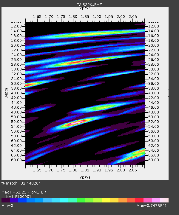
| Estimated Moho Depth: |
52.25 km |
| Estimated Crust Vp/Vs: |
1.81 |
| Assumed Crust Vp: |
6.472 km/s |
| Estimated Crust Vs: |
3.576 km/s |
| Estimated Crust Poisson's Ratio: |
0.28 |
|
| Radial Match: |
82.448204 % |
| Radial Bump: |
400 |
| Transverse Match: |
69.345085 % |
| Transverse Bump: |
400 |
| SOD ConfigId: |
13570011 |
| Insert Time: |
2019-04-28 21:34:33.554 +0000 |
| GWidth: |
2.5 |
| Max Bumps: |
400 |
| Tol: |
0.001 |
|

Signal To Noise
| Channel | StoN | STA | LTA |
| TA:S32K: :BHZ:20170926T04:32:10.200002Z | 6.771494 | 1.3352209E-6 | 1.9718262E-7 |
| TA:S32K: :BHN:20170926T04:32:10.200002Z | 3.133312 | 4.367428E-7 | 1.3938696E-7 |
| TA:S32K: :BHE:20170926T04:32:10.200002Z | 2.2373009 | 3.4486877E-7 | 1.54145E-7 |
| Arrivals |
| Ps | 6.7 SECOND |
| PpPs | 22 SECOND |
| PsPs/PpSs | 29 SECOND |


