You are here: Home > Network List > TA - USArray Transportable Network (new EarthScope stations) Stations List
> Station S34M Telegraph Creek, BC, CAN > Earthquake Result Viewer
S34M Telegraph Creek, BC, CAN - Earthquake Result Viewer
| Earthquake location: |
South Of Fiji Islands |
| Earthquake latitude/longitude: |
-23.7/-176.9 |
| Earthquake time(UTC): |
2017/09/26 (269) 04:20:00 GMT |
| Earthquake Depth: |
98 km |
| Earthquake Magnitude: |
6.4 mww |
| Earthquake Catalog/Contributor: |
NEIC PDE/us |
|
| Network: |
TA USArray Transportable Network (new EarthScope stations) |
| Station: |
S34M Telegraph Creek, BC, CAN |
| Lat/Lon: |
57.91 N/131.13 W |
| Elevation: |
298 m |
|
| Distance: |
89.8 deg |
| Az: |
22.501 deg |
| Baz: |
221.083 deg |
| Ray Param: |
0.041697286 |
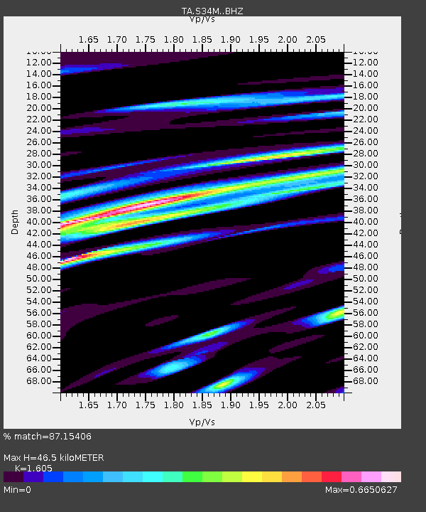
| Estimated Moho Depth: |
46.5 km |
| Estimated Crust Vp/Vs: |
1.61 |
| Assumed Crust Vp: |
6.597 km/s |
| Estimated Crust Vs: |
4.111 km/s |
| Estimated Crust Poisson's Ratio: |
0.18 |
|
| Radial Match: |
87.15406 % |
| Radial Bump: |
400 |
| Transverse Match: |
83.90547 % |
| Transverse Bump: |
400 |
| SOD ConfigId: |
13570011 |
| Insert Time: |
2019-04-28 21:34:34.826 +0000 |
| GWidth: |
2.5 |
| Max Bumps: |
400 |
| Tol: |
0.001 |
|

Signal To Noise
| Channel | StoN | STA | LTA |
| TA:S34M: :BHZ:20170926T04:32:17.299978Z | 12.269596 | 1.385188E-6 | 1.1289598E-7 |
| TA:S34M: :BHN:20170926T04:32:17.299978Z | 3.1172023 | 3.6885237E-7 | 1.1832802E-7 |
| TA:S34M: :BHE:20170926T04:32:17.299978Z | 2.5239215 | 3.322803E-7 | 1.316524E-7 |
| Arrivals |
| Ps | 4.4 SECOND |
| PpPs | 18 SECOND |
| PsPs/PpSs | 22 SECOND |


