You are here: Home > Network List > TA - USArray Transportable Network (new EarthScope stations) Stations List
> Station T25A Trinidad, CO, USA > Earthquake Result Viewer
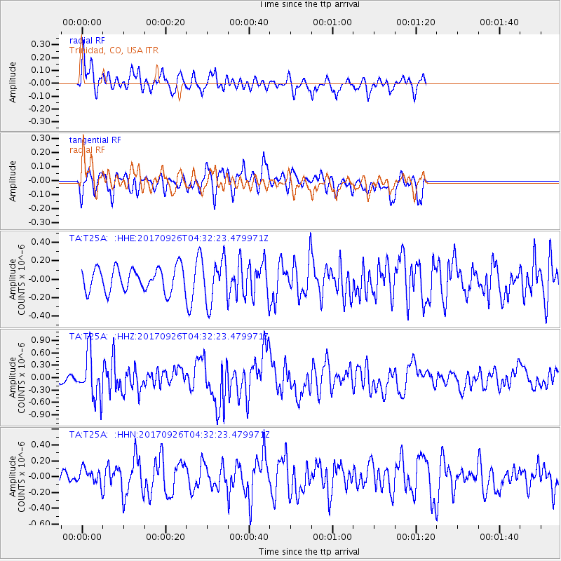
T25A Trinidad, CO, USA - Earthquake Result Viewer
*The percent match for this event was below the threshold and hence no stack was calculated.
| Earthquake location: |
South Of Fiji Islands |
| Earthquake latitude/longitude: |
-23.7/-176.9 |
| Earthquake time(UTC): |
2017/09/26 (269) 04:20:00 GMT |
| Earthquake Depth: |
98 km |
| Earthquake Magnitude: |
6.4 mww |
| Earthquake Catalog/Contributor: |
NEIC PDE/us |
|
| Network: |
TA USArray Transportable Network (new EarthScope stations) |
| Station: |
T25A Trinidad, CO, USA |
| Lat/Lon: |
37.14 N/104.41 W |
| Elevation: |
2017 m |
|
| Distance: |
91.2 deg |
| Az: |
49.677 deg |
| Baz: |
240.979 deg |
| Ray Param: |
$rayparam |
*The percent match for this event was below the threshold and hence was not used in the summary stack. |
|
| Radial Match: |
59.014614 % |
| Radial Bump: |
400 |
| Transverse Match: |
60.55742 % |
| Transverse Bump: |
400 |
| SOD ConfigId: |
13570011 |
| Insert Time: |
2019-04-28 21:34:36.315 +0000 |
| GWidth: |
2.5 |
| Max Bumps: |
400 |
| Tol: |
0.001 |
|
Signal To Noise
| Channel | StoN | STA | LTA |
| TA:T25A: :HHZ:20170926T04:32:23.479971Z | 8.06978 | 5.423053E-7 | 6.7201995E-8 |
| TA:T25A: :HHN:20170926T04:32:23.479971Z | 1.1839116 | 1.0058263E-7 | 8.495789E-8 |
| TA:T25A: :HHE:20170926T04:32:23.479971Z | 1.8117195 | 2.3057015E-7 | 1.2726592E-7 |
| Arrivals |
| Ps | |
| PpPs | |
| PsPs/PpSs | |


