You are here: Home > Network List > TA - USArray Transportable Network (new EarthScope stations) Stations List
> Station U22A Llaves, NM, USA > Earthquake Result Viewer
U22A Llaves, NM, USA - Earthquake Result Viewer
| Earthquake location: |
East Of Kuril Islands |
| Earthquake latitude/longitude: |
46.9/155.2 |
| Earthquake time(UTC): |
2009/01/15 (015) 17:49:39 GMT |
| Earthquake Depth: |
36 km |
| Earthquake Magnitude: |
6.9 MB, 7.5 MS, 7.4 MW, 7.4 MW |
| Earthquake Catalog/Contributor: |
WHDF/NEIC |
|
| Network: |
TA USArray Transportable Network (new EarthScope stations) |
| Station: |
U22A Llaves, NM, USA |
| Lat/Lon: |
36.38 N/106.85 W |
| Elevation: |
2119 m |
|
| Distance: |
69.4 deg |
| Az: |
58.651 deg |
| Baz: |
313.43 deg |
| Ray Param: |
0.055641692 |
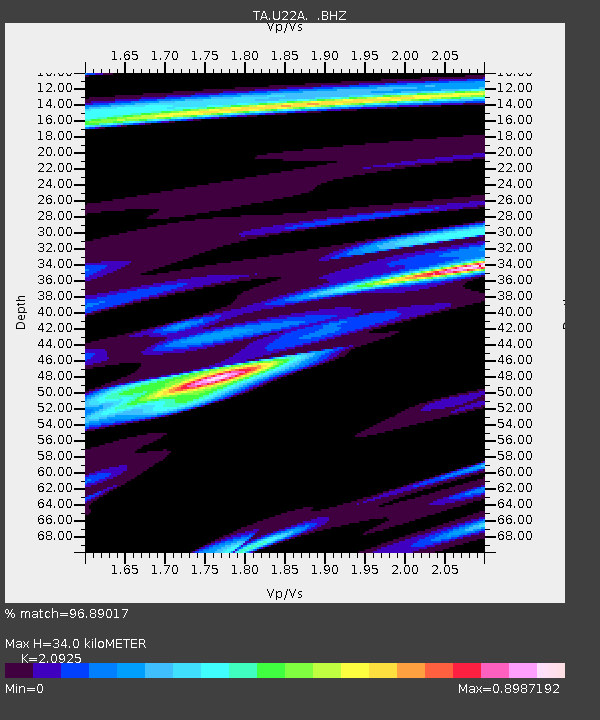
| Estimated Moho Depth: |
34.0 km |
| Estimated Crust Vp/Vs: |
2.09 |
| Assumed Crust Vp: |
6.159 km/s |
| Estimated Crust Vs: |
2.943 km/s |
| Estimated Crust Poisson's Ratio: |
0.35 |
|
| Radial Match: |
96.89017 % |
| Radial Bump: |
400 |
| Transverse Match: |
93.796745 % |
| Transverse Bump: |
399 |
| SOD ConfigId: |
2834 |
| Insert Time: |
2010-03-06 04:22:21.437 +0000 |
| GWidth: |
2.5 |
| Max Bumps: |
400 |
| Tol: |
0.001 |
|
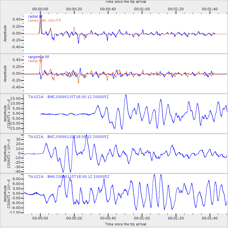
Signal To Noise
| Channel | StoN | STA | LTA |
| TA:U22A: :BHZ:20090115T18:00:12.200005Z | 18.495344 | 1.1280036E-5 | 6.098852E-7 |
| TA:U22A: :BHN:20090115T18:00:12.200005Z | 5.7860875 | 2.8071547E-6 | 4.8515597E-7 |
| TA:U22A: :BHE:20090115T18:00:12.200005Z | 10.084304 | 4.217811E-6 | 4.18255E-7 |
| Arrivals |
| Ps | 6.2 SECOND |
| PpPs | 17 SECOND |
| PsPs/PpSs | 23 SECOND |


