You are here: Home > Network List > TA - USArray Transportable Network (new EarthScope stations) Stations List
> Station U22A Llaves, NM, USA > Earthquake Result Viewer
U22A Llaves, NM, USA - Earthquake Result Viewer

| Earthquake location: |
Southeast Of Honshu, Japan |
| Earthquake latitude/longitude: |
32.8/140.4 |
| Earthquake time(UTC): |
2009/08/12 (224) 22:48:51 GMT |
| Earthquake Depth: |
53 km |
| Earthquake Magnitude: |
6.2 MB, 6.6 MW, 6.6 MW |
| Earthquake Catalog/Contributor: |
WHDF/NEIC |
|
| Network: |
TA USArray Transportable Network (new EarthScope stations) |
| Station: |
U22A Llaves, NM, USA |
| Lat/Lon: |
36.38 N/106.85 W |
| Elevation: |
2119 m |
|
| Distance: |
86.8 deg |
| Az: |
48.193 deg |
| Baz: |
308.948 deg |
| Ray Param: |
0.043693434 |
| Estimated Moho Depth: |
48.0 km |
| Estimated Crust Vp/Vs: |
1.72 |
| Assumed Crust Vp: |
6.159 km/s |
| Estimated Crust Vs: |
3.586 km/s |
| Estimated Crust Poisson's Ratio: |
0.24 |
|
| Radial Match: |
91.858734 % |
| Radial Bump: |
366 |
| Transverse Match: |
81.59268 % |
| Transverse Bump: |
400 |
| SOD ConfigId: |
2622 |
| Insert Time: |
2010-03-06 04:22:27.321 +0000 |
| GWidth: |
2.5 |
| Max Bumps: |
400 |
| Tol: |
0.001 |
|
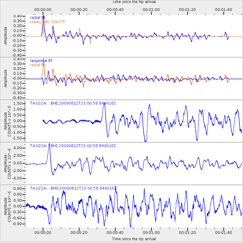
Signal To Noise
| Channel | StoN | STA | LTA |
| TA:U22A: :BHZ:20090812T23:00:58.849016Z | 28.753132 | 2.1714193E-6 | 7.55194E-8 |
| TA:U22A: :BHN:20090812T23:00:58.849016Z | 6.429504 | 4.0566002E-7 | 6.3093516E-8 |
| TA:U22A: :BHE:20090812T23:00:58.849016Z | 7.9218807 | 6.8918814E-7 | 8.699805E-8 |
| Arrivals |
| Ps | 5.7 SECOND |
| PpPs | 21 SECOND |
| PsPs/PpSs | 26 SECOND |


