You are here: Home > Network List > TA - USArray Transportable Network (new EarthScope stations) Stations List
> Station U22A Llaves, NM, USA > Earthquake Result Viewer
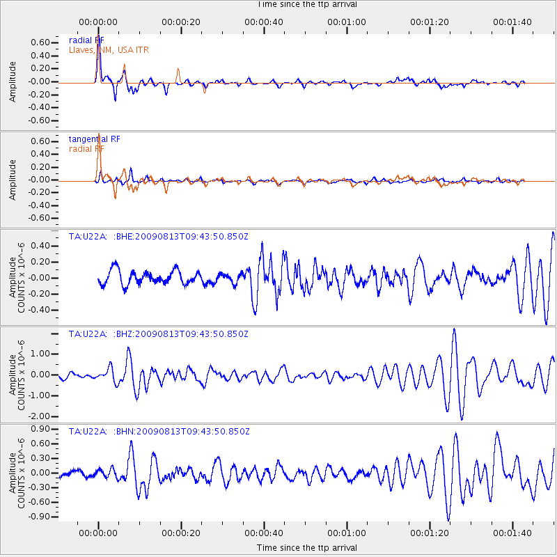
U22A Llaves, NM, USA - Earthquake Result Viewer

| Earthquake location: |
Off Coast Of Costa Rica |
| Earthquake latitude/longitude: |
7.9/-85.6 |
| Earthquake time(UTC): |
2009/08/13 (225) 09:37:35 GMT |
| Earthquake Depth: |
10 km |
| Earthquake Magnitude: |
5.8 MW, 5.3 MB |
| Earthquake Catalog/Contributor: |
WHDF/NEIC |
|
| Network: |
TA USArray Transportable Network (new EarthScope stations) |
| Station: |
U22A Llaves, NM, USA |
| Lat/Lon: |
36.38 N/106.85 W |
| Elevation: |
2119 m |
|
| Distance: |
34.3 deg |
| Az: |
328.759 deg |
| Baz: |
140.464 deg |
| Ray Param: |
0.07781935 |
| Estimated Moho Depth: |
14.5 km |
| Estimated Crust Vp/Vs: |
1.90 |
| Assumed Crust Vp: |
6.159 km/s |
| Estimated Crust Vs: |
3.241 km/s |
| Estimated Crust Poisson's Ratio: |
0.31 |
|
| Radial Match: |
84.11197 % |
| Radial Bump: |
381 |
| Transverse Match: |
76.54708 % |
| Transverse Bump: |
301 |
| SOD ConfigId: |
2622 |
| Insert Time: |
2010-03-06 04:22:29.179 +0000 |
| GWidth: |
2.5 |
| Max Bumps: |
400 |
| Tol: |
0.001 |
|
Signal To Noise
| Channel | StoN | STA | LTA |
| TA:U22A: :BHZ:20090813T09:43:50.850Z | 3.4782774 | 3.2968006E-7 | 9.4782564E-8 |
| TA:U22A: :BHN:20090813T09:43:50.850Z | 1.605452 | 8.8488655E-8 | 5.51176E-8 |
| TA:U22A: :BHE:20090813T09:43:50.850Z | 0.6801414 | 5.7500788E-8 | 8.45424E-8 |
| Arrivals |
| Ps | 2.3 SECOND |
| PpPs | 6.4 SECOND |
| PsPs/PpSs | 8.7 SECOND |


