You are here: Home > Network List > UW - Pacific Northwest Regional Seismic Network Stations List
> Station IZEE Izee, OR, USA > Earthquake Result Viewer
IZEE Izee, OR, USA - Earthquake Result Viewer
| Earthquake location: |
South Of Fiji Islands |
| Earthquake latitude/longitude: |
-23.7/-176.9 |
| Earthquake time(UTC): |
2017/09/26 (269) 04:20:00 GMT |
| Earthquake Depth: |
98 km |
| Earthquake Magnitude: |
6.4 mww |
| Earthquake Catalog/Contributor: |
NEIC PDE/us |
|
| Network: |
UW Pacific Northwest Regional Seismic Network |
| Station: |
IZEE Izee, OR, USA |
| Lat/Lon: |
44.08 N/119.50 W |
| Elevation: |
1293 m |
|
| Distance: |
85.5 deg |
| Az: |
37.534 deg |
| Baz: |
230.788 deg |
| Ray Param: |
0.044507954 |
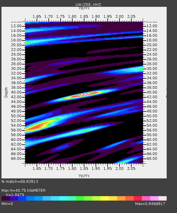
| Estimated Moho Depth: |
40.75 km |
| Estimated Crust Vp/Vs: |
1.85 |
| Assumed Crust Vp: |
6.571 km/s |
| Estimated Crust Vs: |
3.557 km/s |
| Estimated Crust Poisson's Ratio: |
0.29 |
|
| Radial Match: |
88.92913 % |
| Radial Bump: |
400 |
| Transverse Match: |
99.72027 % |
| Transverse Bump: |
51 |
| SOD ConfigId: |
13570011 |
| Insert Time: |
2019-04-28 21:35:41.457 +0000 |
| GWidth: |
2.5 |
| Max Bumps: |
400 |
| Tol: |
0.001 |
|

Signal To Noise
| Channel | StoN | STA | LTA |
| UW:IZEE: :HHZ:20170926T04:31:56.648Z | 7.6548033 | 8.175626E-7 | 1.0680386E-7 |
| UW:IZEE: :HHN:20170926T04:31:56.648Z | 8.702363 | 6.048955E-7 | 6.950934E-8 |
| UW:IZEE: :HHE:20170926T04:31:56.648Z | 3.712277 | 2.171118E-7 | 5.8484808E-8 |
| Arrivals |
| Ps | 5.4 SECOND |
| PpPs | 17 SECOND |
| PsPs/PpSs | 23 SECOND |


