You are here: Home > Network List > CI - Caltech Regional Seismic Network Stations List
> Station SMM Simmler, CA, USA > Earthquake Result Viewer
SMM Simmler, CA, USA - Earthquake Result Viewer
| Earthquake location: |
Off Coast Of Costa Rica |
| Earthquake latitude/longitude: |
10.7/-87.0 |
| Earthquake time(UTC): |
2004/06/29 (181) 07:01:30 GMT |
| Earthquake Depth: |
9.0 km |
| Earthquake Magnitude: |
5.8 MB, 5.8 MS, 6.3 MW, 6.1 MW |
| Earthquake Catalog/Contributor: |
WHDF/NEIC |
|
| Network: |
CI Caltech Regional Seismic Network |
| Station: |
SMM Simmler, CA, USA |
| Lat/Lon: |
35.31 N/120.00 W |
| Elevation: |
599 m |
|
| Distance: |
38.7 deg |
| Az: |
314.588 deg |
| Baz: |
121.155 deg |
| Ray Param: |
0.07543878 |
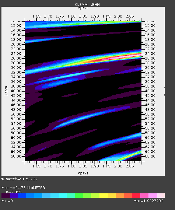
| Estimated Moho Depth: |
24.75 km |
| Estimated Crust Vp/Vs: |
2.06 |
| Assumed Crust Vp: |
6.1 km/s |
| Estimated Crust Vs: |
2.968 km/s |
| Estimated Crust Poisson's Ratio: |
0.34 |
|
| Radial Match: |
91.53722 % |
| Radial Bump: |
400 |
| Transverse Match: |
86.676155 % |
| Transverse Bump: |
400 |
| SOD ConfigId: |
2459 |
| Insert Time: |
2010-02-26 01:29:40.067 +0000 |
| GWidth: |
2.5 |
| Max Bumps: |
400 |
| Tol: |
0.001 |
|
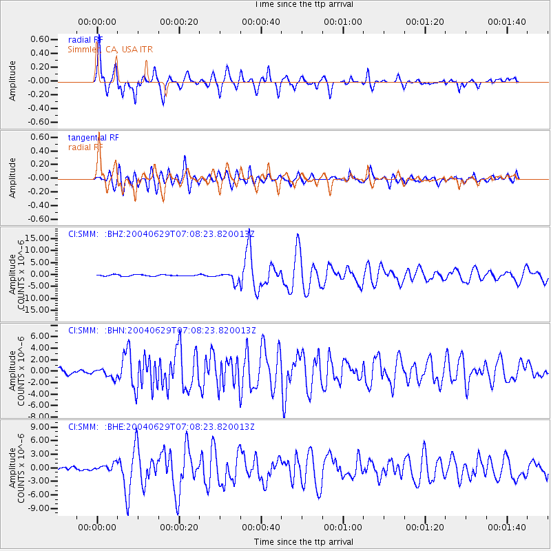
Signal To Noise
| Channel | StoN | STA | LTA |
| CI:SMM: :BHN:20040629T07:08:23.820013Z | 1.5178924 | 7.994874E-7 | 5.267089E-7 |
| CI:SMM: :BHE:20040629T07:08:23.820013Z | 1.7016917 | 8.001358E-7 | 4.7020018E-7 |
| CI:SMM: :BHZ:20040629T07:08:23.820013Z | 6.9789114 | 2.0899965E-6 | 2.9947313E-7 |
| Arrivals |
| Ps | 4.5 SECOND |
| PpPs | 12 SECOND |
| PsPs/PpSs | 16 SECOND |


