You are here: Home > Network List > TA - USArray Transportable Network (new EarthScope stations) Stations List
> Station U22A Llaves, NM, USA > Earthquake Result Viewer
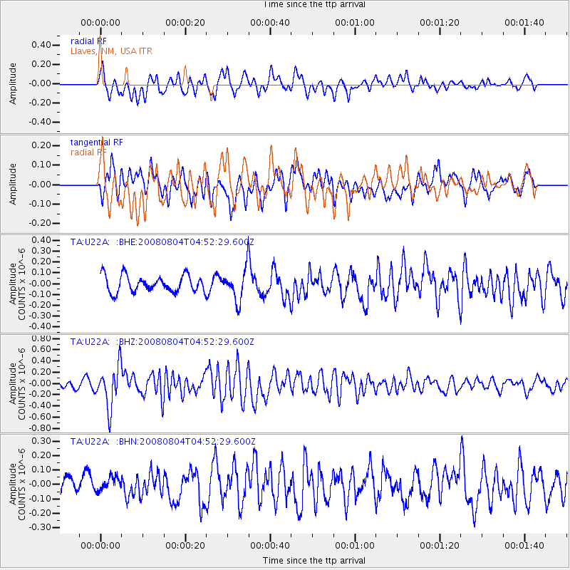
U22A Llaves, NM, USA - Earthquake Result Viewer
*The percent match for this event was below the threshold and hence no stack was calculated.
| Earthquake location: |
Kuril Islands |
| Earthquake latitude/longitude: |
49.9/156.4 |
| Earthquake time(UTC): |
2008/08/04 (217) 04:42:14 GMT |
| Earthquake Depth: |
77 km |
| Earthquake Magnitude: |
5.6 MB, 5.8 MW, 5.7 MW |
| Earthquake Catalog/Contributor: |
WHDF/NEIC |
|
| Network: |
TA USArray Transportable Network (new EarthScope stations) |
| Station: |
U22A Llaves, NM, USA |
| Lat/Lon: |
36.38 N/106.85 W |
| Elevation: |
2119 m |
|
| Distance: |
67.1 deg |
| Az: |
60.43 deg |
| Baz: |
315.765 deg |
| Ray Param: |
$rayparam |
*The percent match for this event was below the threshold and hence was not used in the summary stack. |
|
| Radial Match: |
67.2171 % |
| Radial Bump: |
400 |
| Transverse Match: |
61.975624 % |
| Transverse Bump: |
400 |
| SOD ConfigId: |
2504 |
| Insert Time: |
2010-03-06 04:24:58.365 +0000 |
| GWidth: |
2.5 |
| Max Bumps: |
400 |
| Tol: |
0.001 |
|
Signal To Noise
| Channel | StoN | STA | LTA |
| TA:U22A: :BHZ:20080804T04:52:29.600Z | 5.725743 | 3.7311247E-7 | 6.516403E-8 |
| TA:U22A: :BHN:20080804T04:52:29.600Z | 0.78346545 | 4.7669978E-8 | 6.0845025E-8 |
| TA:U22A: :BHE:20080804T04:52:29.600Z | 2.0064619 | 1.5310735E-7 | 7.630713E-8 |
| Arrivals |
| Ps | |
| PpPs | |
| PsPs/PpSs | |


