You are here: Home > Network List > TA - USArray Transportable Network (new EarthScope stations) Stations List
> Station U22A Llaves, NM, USA > Earthquake Result Viewer
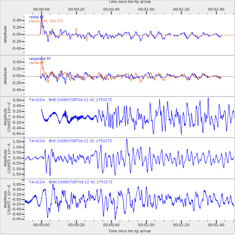
U22A Llaves, NM, USA - Earthquake Result Viewer
*The percent match for this event was below the threshold and hence no stack was calculated.
| Earthquake location: |
Southern Peru |
| Earthquake latitude/longitude: |
-16.0/-71.7 |
| Earthquake time(UTC): |
2008/07/08 (190) 09:13:07 GMT |
| Earthquake Depth: |
123 km |
| Earthquake Magnitude: |
5.8 MB, 6.2 MW, 6.2 MW |
| Earthquake Catalog/Contributor: |
WHDF/NEIC |
|
| Network: |
TA USArray Transportable Network (new EarthScope stations) |
| Station: |
U22A Llaves, NM, USA |
| Lat/Lon: |
36.38 N/106.85 W |
| Elevation: |
2119 m |
|
| Distance: |
61.7 deg |
| Az: |
328.204 deg |
| Baz: |
141.101 deg |
| Ray Param: |
$rayparam |
*The percent match for this event was below the threshold and hence was not used in the summary stack. |
|
| Radial Match: |
79.32986 % |
| Radial Bump: |
400 |
| Transverse Match: |
67.439964 % |
| Transverse Bump: |
400 |
| SOD ConfigId: |
2504 |
| Insert Time: |
2010-03-06 04:25:14.239 +0000 |
| GWidth: |
2.5 |
| Max Bumps: |
400 |
| Tol: |
0.001 |
|
Signal To Noise
| Channel | StoN | STA | LTA |
| TA:U22A: :BHZ:20080708T09:22:42.175027Z | 4.683158 | 5.184209E-7 | 1.10699006E-7 |
| TA:U22A: :BHN:20080708T09:22:42.175027Z | 3.3947031 | 3.6432192E-7 | 1.07320695E-7 |
| TA:U22A: :BHE:20080708T09:22:42.175027Z | 1.025776 | 1.0652347E-7 | 1.0384672E-7 |
| Arrivals |
| Ps | |
| PpPs | |
| PsPs/PpSs | |


