You are here: Home > Network List > CI - Caltech Regional Seismic Network Stations List
> Station MPM Manuel Prospect Mine, California, USA > Earthquake Result Viewer
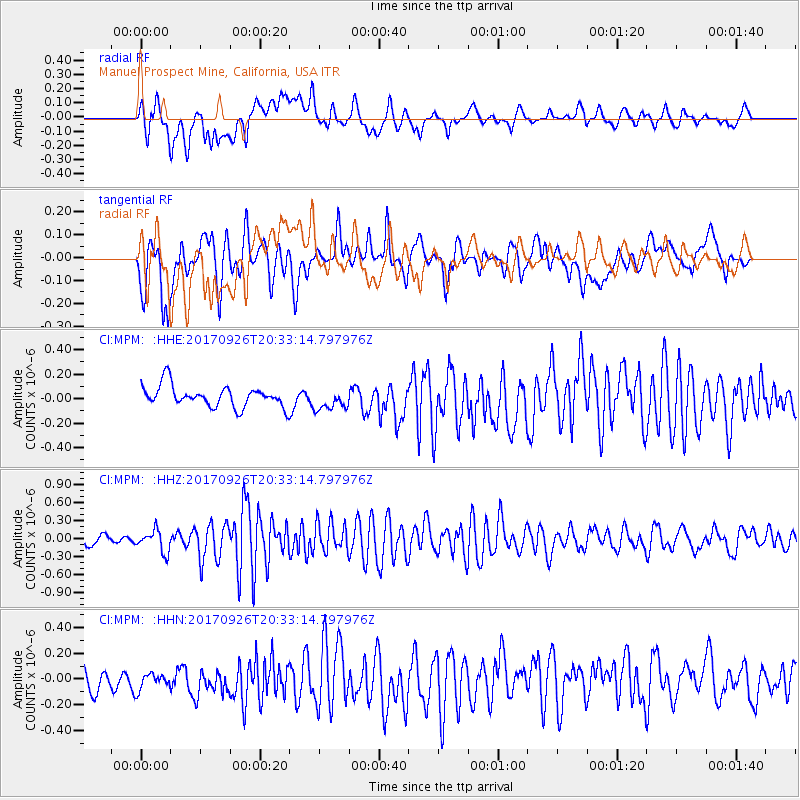
MPM Manuel Prospect Mine, California, USA - Earthquake Result Viewer
*The percent match for this event was below the threshold and hence no stack was calculated.
| Earthquake location: |
Near East Coast Of Honshu, Japan |
| Earthquake latitude/longitude: |
40.3/142.4 |
| Earthquake time(UTC): |
2017/09/26 (269) 20:22:11 GMT |
| Earthquake Depth: |
36 km |
| Earthquake Magnitude: |
5.8 Mww |
| Earthquake Catalog/Contributor: |
NEIC PDE/us |
|
| Network: |
CI Caltech Regional Seismic Network |
| Station: |
MPM Manuel Prospect Mine, California, USA |
| Lat/Lon: |
36.06 N/117.49 W |
| Elevation: |
185 m |
|
| Distance: |
74.4 deg |
| Az: |
55.92 deg |
| Baz: |
308.6 deg |
| Ray Param: |
$rayparam |
*The percent match for this event was below the threshold and hence was not used in the summary stack. |
|
| Radial Match: |
76.573105 % |
| Radial Bump: |
400 |
| Transverse Match: |
69.82407 % |
| Transverse Bump: |
400 |
| SOD ConfigId: |
13570011 |
| Insert Time: |
2019-04-28 21:39:48.051 +0000 |
| GWidth: |
2.5 |
| Max Bumps: |
400 |
| Tol: |
0.001 |
|
Signal To Noise
| Channel | StoN | STA | LTA |
| CI:MPM: :HHZ:20170926T20:33:14.797976Z | 2.534794 | 1.8175294E-7 | 7.1703234E-8 |
| CI:MPM: :HHN:20170926T20:33:14.797976Z | 0.7945731 | 6.716968E-8 | 8.453556E-8 |
| CI:MPM: :HHE:20170926T20:33:14.797976Z | 0.9998889 | 8.669319E-8 | 8.6702826E-8 |
| Arrivals |
| Ps | |
| PpPs | |
| PsPs/PpSs | |


