You are here: Home > Network List > TA - USArray Transportable Network (new EarthScope stations) Stations List
> Station U22A Llaves, NM, USA > Earthquake Result Viewer
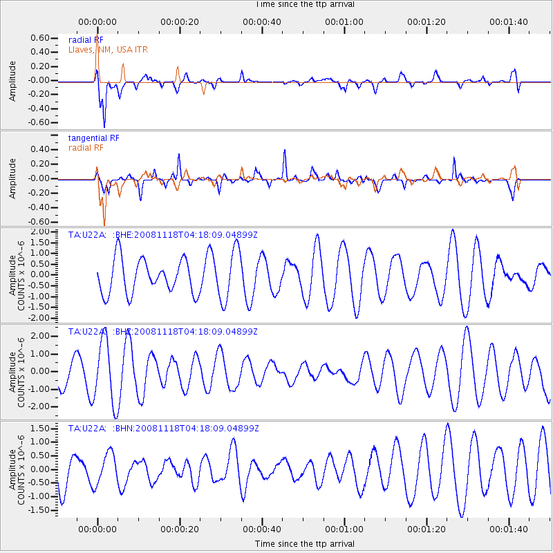
U22A Llaves, NM, USA - Earthquake Result Viewer
*The percent match for this event was below the threshold and hence no stack was calculated.
| Earthquake location: |
Arctic Ocean |
| Earthquake latitude/longitude: |
79.8/-115.9 |
| Earthquake time(UTC): |
2008/11/18 (323) 04:10:35 GMT |
| Earthquake Depth: |
10 km |
| Earthquake Magnitude: |
5.5 ML, 5.2 MB |
| Earthquake Catalog/Contributor: |
WHDF/NEIC |
|
| Network: |
TA USArray Transportable Network (new EarthScope stations) |
| Station: |
U22A Llaves, NM, USA |
| Lat/Lon: |
36.38 N/106.85 W |
| Elevation: |
2119 m |
|
| Distance: |
43.7 deg |
| Az: |
169.443 deg |
| Baz: |
357.673 deg |
| Ray Param: |
$rayparam |
*The percent match for this event was below the threshold and hence was not used in the summary stack. |
|
| Radial Match: |
63.35779 % |
| Radial Bump: |
400 |
| Transverse Match: |
63.736862 % |
| Transverse Bump: |
339 |
| SOD ConfigId: |
2658 |
| Insert Time: |
2010-03-06 04:25:38.651 +0000 |
| GWidth: |
2.5 |
| Max Bumps: |
400 |
| Tol: |
0.001 |
|
Signal To Noise
| Channel | StoN | STA | LTA |
| TA:U22A: :BHZ:20081118T04:18:09.04899Z | 2.3654556 | 1.8332469E-6 | 7.7500795E-7 |
| TA:U22A: :BHN:20081118T04:18:09.04899Z | 0.6025635 | 5.717769E-7 | 9.489073E-7 |
| TA:U22A: :BHE:20081118T04:18:09.04899Z | 1.550082 | 1.2095552E-6 | 7.803169E-7 |
| Arrivals |
| Ps | |
| PpPs | |
| PsPs/PpSs | |


