You are here: Home > Network List > CN - Canadian National Seismograph Network Stations List
> Station INK INUVIK, NT > Earthquake Result Viewer
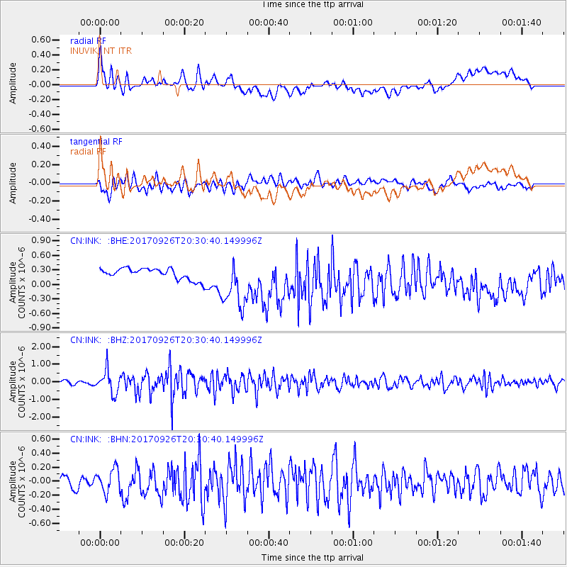
INK INUVIK, NT - Earthquake Result Viewer
*The percent match for this event was below the threshold and hence no stack was calculated.
| Earthquake location: |
Near East Coast Of Honshu, Japan |
| Earthquake latitude/longitude: |
40.3/142.4 |
| Earthquake time(UTC): |
2017/09/26 (269) 20:22:11 GMT |
| Earthquake Depth: |
36 km |
| Earthquake Magnitude: |
5.8 Mww |
| Earthquake Catalog/Contributor: |
NEIC PDE/us |
|
| Network: |
CN Canadian National Seismograph Network |
| Station: |
INK INUVIK, NT |
| Lat/Lon: |
68.31 N/133.53 W |
| Elevation: |
44 m |
|
| Distance: |
51.1 deg |
| Az: |
28.362 deg |
| Baz: |
282.334 deg |
| Ray Param: |
$rayparam |
*The percent match for this event was below the threshold and hence was not used in the summary stack. |
|
| Radial Match: |
58.316776 % |
| Radial Bump: |
400 |
| Transverse Match: |
64.22869 % |
| Transverse Bump: |
400 |
| SOD ConfigId: |
13570011 |
| Insert Time: |
2019-04-28 21:40:14.919 +0000 |
| GWidth: |
2.5 |
| Max Bumps: |
400 |
| Tol: |
0.001 |
|
Signal To Noise
| Channel | StoN | STA | LTA |
| CN:INK: :BHZ:20170926T20:30:40.149996Z | 8.662342 | 6.6876936E-7 | 7.720422E-8 |
| CN:INK: :BHN:20170926T20:30:40.149996Z | 1.7732124 | 1.6679134E-7 | 9.4061676E-8 |
| CN:INK: :BHE:20170926T20:30:40.149996Z | 4.6228404 | 5.3227393E-7 | 1.1514002E-7 |
| Arrivals |
| Ps | |
| PpPs | |
| PsPs/PpSs | |


