You are here: Home > Network List > TA - USArray Transportable Network (new EarthScope stations) Stations List
> Station U22A Llaves, NM, USA > Earthquake Result Viewer
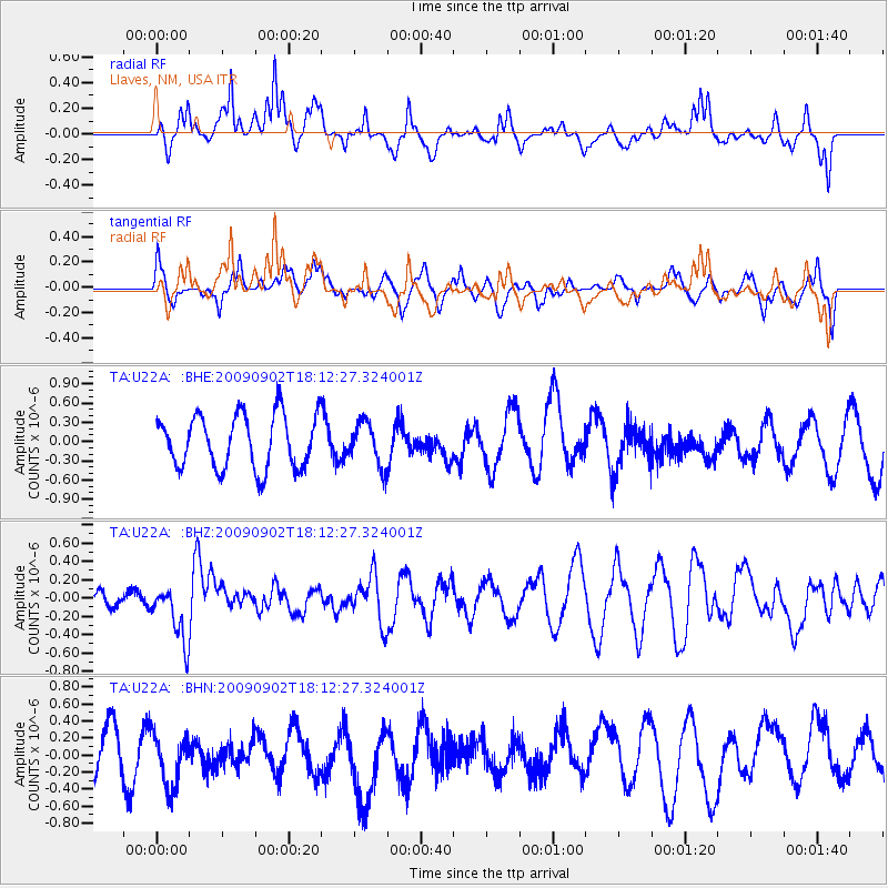
U22A Llaves, NM, USA - Earthquake Result Viewer
*The percent match for this event was below the threshold and hence no stack was calculated.
| Earthquake location: |
Kermadec Islands, New Zealand |
| Earthquake latitude/longitude: |
-29.4/-179.0 |
| Earthquake time(UTC): |
2009/09/02 (245) 18:00:11 GMT |
| Earthquake Depth: |
275 km |
| Earthquake Magnitude: |
5.8 MB, 6.2 MW, 6.1 MW |
| Earthquake Catalog/Contributor: |
WHDF/NEIC |
|
| Network: |
TA USArray Transportable Network (new EarthScope stations) |
| Station: |
U22A Llaves, NM, USA |
| Lat/Lon: |
36.38 N/106.85 W |
| Elevation: |
2119 m |
|
| Distance: |
94.1 deg |
| Az: |
50.349 deg |
| Baz: |
236.396 deg |
| Ray Param: |
$rayparam |
*The percent match for this event was below the threshold and hence was not used in the summary stack. |
|
| Radial Match: |
74.71192 % |
| Radial Bump: |
332 |
| Transverse Match: |
51.237816 % |
| Transverse Bump: |
322 |
| SOD ConfigId: |
2622 |
| Insert Time: |
2010-03-06 04:25:43.164 +0000 |
| GWidth: |
2.5 |
| Max Bumps: |
400 |
| Tol: |
0.001 |
|
Signal To Noise
| Channel | StoN | STA | LTA |
| TA:U22A: :BHZ:20090902T18:12:27.324001Z | 3.3467453 | 3.119828E-7 | 9.321976E-8 |
| TA:U22A: :BHN:20090902T18:12:27.324001Z | 1.0382551 | 3.2020526E-7 | 3.0840712E-7 |
| TA:U22A: :BHE:20090902T18:12:27.324001Z | 0.8111395 | 3.3426582E-7 | 4.1209412E-7 |
| Arrivals |
| Ps | |
| PpPs | |
| PsPs/PpSs | |


