You are here: Home > Network List > CI - Caltech Regional Seismic Network Stations List
> Station SMM Simmler, CA, USA > Earthquake Result Viewer
SMM Simmler, CA, USA - Earthquake Result Viewer
| Earthquake location: |
Mariana Islands |
| Earthquake latitude/longitude: |
16.0/145.9 |
| Earthquake time(UTC): |
2005/02/05 (036) 03:34:25 GMT |
| Earthquake Depth: |
143 km |
| Earthquake Magnitude: |
6.3 MB, 6.6 MW, 6.5 MW |
| Earthquake Catalog/Contributor: |
WHDF/NEIC |
|
| Network: |
CI Caltech Regional Seismic Network |
| Station: |
SMM Simmler, CA, USA |
| Lat/Lon: |
35.31 N/120.00 W |
| Elevation: |
599 m |
|
| Distance: |
84.2 deg |
| Az: |
55.073 deg |
| Baz: |
285.394 deg |
| Ray Param: |
0.04532286 |
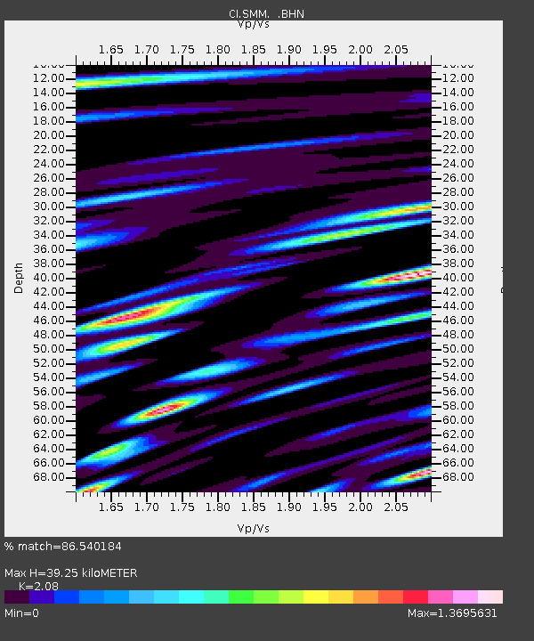
| Estimated Moho Depth: |
39.25 km |
| Estimated Crust Vp/Vs: |
2.08 |
| Assumed Crust Vp: |
6.1 km/s |
| Estimated Crust Vs: |
2.933 km/s |
| Estimated Crust Poisson's Ratio: |
0.35 |
|
| Radial Match: |
86.540184 % |
| Radial Bump: |
400 |
| Transverse Match: |
81.33172 % |
| Transverse Bump: |
400 |
| SOD ConfigId: |
5233 |
| Insert Time: |
2010-02-26 01:29:49.186 +0000 |
| GWidth: |
2.5 |
| Max Bumps: |
400 |
| Tol: |
0.001 |
|
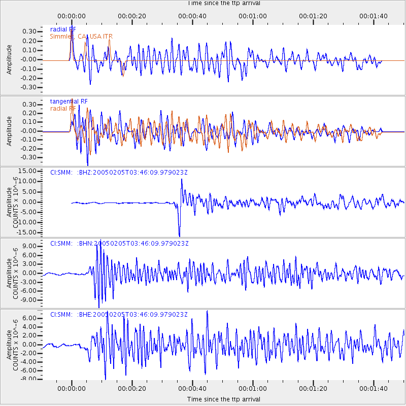
Signal To Noise
| Channel | StoN | STA | LTA |
| CI:SMM: :BHN:20050205T03:46:09.979023Z | 0.5879526 | 1.7435536E-7 | 2.9654663E-7 |
| CI:SMM: :BHE:20050205T03:46:09.979023Z | 1.2193286 | 4.0035016E-7 | 3.2833654E-7 |
| CI:SMM: :BHZ:20050205T03:46:09.979023Z | 3.6694064 | 6.4369E-7 | 1.7542074E-7 |
| Arrivals |
| Ps | 7.1 SECOND |
| PpPs | 19 SECOND |
| PsPs/PpSs | 27 SECOND |


