You are here: Home > Network List > KZ - Kazakhstan Network Stations List
> Station MAKZ Makanchi, Kazakstan > Earthquake Result Viewer
MAKZ Makanchi, Kazakstan - Earthquake Result Viewer
| Earthquake location: |
Near East Coast Of Honshu, Japan |
| Earthquake latitude/longitude: |
40.3/142.4 |
| Earthquake time(UTC): |
2017/09/26 (269) 20:22:11 GMT |
| Earthquake Depth: |
36 km |
| Earthquake Magnitude: |
5.8 Mww |
| Earthquake Catalog/Contributor: |
NEIC PDE/us |
|
| Network: |
KZ Kazakhstan Network |
| Station: |
MAKZ Makanchi, Kazakstan |
| Lat/Lon: |
46.81 N/81.98 E |
| Elevation: |
600 m |
|
| Distance: |
43.3 deg |
| Az: |
299.44 deg |
| Baz: |
75.781 deg |
| Ray Param: |
0.07255387 |
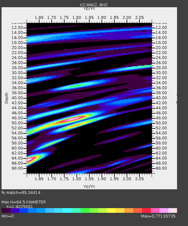
| Estimated Moho Depth: |
64.5 km |
| Estimated Crust Vp/Vs: |
1.60 |
| Assumed Crust Vp: |
6.571 km/s |
| Estimated Crust Vs: |
4.1 km/s |
| Estimated Crust Poisson's Ratio: |
0.18 |
|
| Radial Match: |
95.34414 % |
| Radial Bump: |
400 |
| Transverse Match: |
84.11429 % |
| Transverse Bump: |
400 |
| SOD ConfigId: |
13570011 |
| Insert Time: |
2019-04-28 21:42:15.236 +0000 |
| GWidth: |
2.5 |
| Max Bumps: |
400 |
| Tol: |
0.001 |
|

Signal To Noise
| Channel | StoN | STA | LTA |
| KZ:MAKZ: :BHZ:20170926T20:29:39.500002Z | 39.8501 | 1.9909248E-6 | 4.9960345E-8 |
| KZ:MAKZ: :BHN:20170926T20:29:39.500002Z | 14.936605 | 4.339678E-7 | 2.9053979E-8 |
| KZ:MAKZ: :BHE:20170926T20:29:39.500002Z | 27.62737 | 1.0498217E-6 | 3.7999335E-8 |
| Arrivals |
| Ps | 6.4 SECOND |
| PpPs | 24 SECOND |
| PsPs/PpSs | 30 SECOND |


