You are here: Home > Network List > TA - USArray Transportable Network (new EarthScope stations) Stations List
> Station U22A Llaves, NM, USA > Earthquake Result Viewer
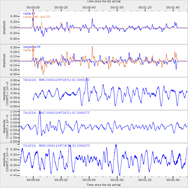
U22A Llaves, NM, USA - Earthquake Result Viewer
*The percent match for this event was below the threshold and hence no stack was calculated.
| Earthquake location: |
Azores Islands Region |
| Earthquake latitude/longitude: |
36.2/-33.9 |
| Earthquake time(UTC): |
2009/11/04 (308) 18:41:44 GMT |
| Earthquake Depth: |
10 km |
| Earthquake Magnitude: |
5.7 MB, 5.6 MS, 5.9 MW, 5.8 MW |
| Earthquake Catalog/Contributor: |
WHDF/NEIC |
|
| Network: |
TA USArray Transportable Network (new EarthScope stations) |
| Station: |
U22A Llaves, NM, USA |
| Lat/Lon: |
36.38 N/106.85 W |
| Elevation: |
2119 m |
|
| Distance: |
57.5 deg |
| Az: |
293.726 deg |
| Baz: |
66.646 deg |
| Ray Param: |
$rayparam |
*The percent match for this event was below the threshold and hence was not used in the summary stack. |
|
| Radial Match: |
58.408714 % |
| Radial Bump: |
364 |
| Transverse Match: |
67.193954 % |
| Transverse Bump: |
400 |
| SOD ConfigId: |
2622 |
| Insert Time: |
2010-03-06 04:26:02.824 +0000 |
| GWidth: |
2.5 |
| Max Bumps: |
400 |
| Tol: |
0.001 |
|
Signal To Noise
| Channel | StoN | STA | LTA |
| TA:U22A: :BHZ:20091104T18:51:02.200027Z | 5.836087 | 8.578118E-7 | 1.4698406E-7 |
| TA:U22A: :BHN:20091104T18:51:02.200027Z | 1.3240749 | 2.3249648E-7 | 1.7559162E-7 |
| TA:U22A: :BHE:20091104T18:51:02.200027Z | 1.6703186 | 3.0766446E-7 | 1.8419507E-7 |
| Arrivals |
| Ps | |
| PpPs | |
| PsPs/PpSs | |


