You are here: Home > Network List > TA - USArray Transportable Network (new EarthScope stations) Stations List
> Station U22A Llaves, NM, USA > Earthquake Result Viewer
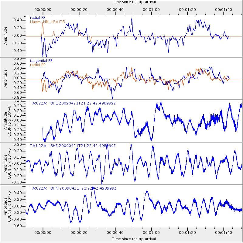
U22A Llaves, NM, USA - Earthquake Result Viewer
*The percent match for this event was below the threshold and hence no stack was calculated.
| Earthquake location: |
Santa Cruz Islands |
| Earthquake latitude/longitude: |
-10.8/166.0 |
| Earthquake time(UTC): |
2009/04/21 (111) 21:09:59 GMT |
| Earthquake Depth: |
35 km |
| Earthquake Magnitude: |
5.7 MW, 5.0 MS, 5.3 MB, 5.7 MW |
| Earthquake Catalog/Contributor: |
WHDF/NEIC |
|
| Network: |
TA USArray Transportable Network (new EarthScope stations) |
| Station: |
U22A Llaves, NM, USA |
| Lat/Lon: |
36.38 N/106.85 W |
| Elevation: |
2119 m |
|
| Distance: |
94.0 deg |
| Az: |
53.9 deg |
| Baz: |
259.641 deg |
| Ray Param: |
$rayparam |
*The percent match for this event was below the threshold and hence was not used in the summary stack. |
|
| Radial Match: |
57.24842 % |
| Radial Bump: |
400 |
| Transverse Match: |
57.038315 % |
| Transverse Bump: |
400 |
| SOD ConfigId: |
2658 |
| Insert Time: |
2010-03-06 04:26:22.351 +0000 |
| GWidth: |
2.5 |
| Max Bumps: |
400 |
| Tol: |
0.001 |
|
Signal To Noise
| Channel | StoN | STA | LTA |
| TA:U22A: :BHZ:20090421T21:22:42.498999Z | 1.5183009 | 9.8466465E-8 | 6.485306E-8 |
| TA:U22A: :BHN:20090421T21:22:42.498999Z | 0.5564921 | 8.979864E-8 | 1.6136553E-7 |
| TA:U22A: :BHE:20090421T21:22:42.498999Z | 1.2766768 | 2.3386161E-7 | 1.8317998E-7 |
| Arrivals |
| Ps | |
| PpPs | |
| PsPs/PpSs | |


