You are here: Home > Network List > TA - USArray Transportable Network (new EarthScope stations) Stations List
> Station B22K Teshekpuk Lake, AK, USA > Earthquake Result Viewer
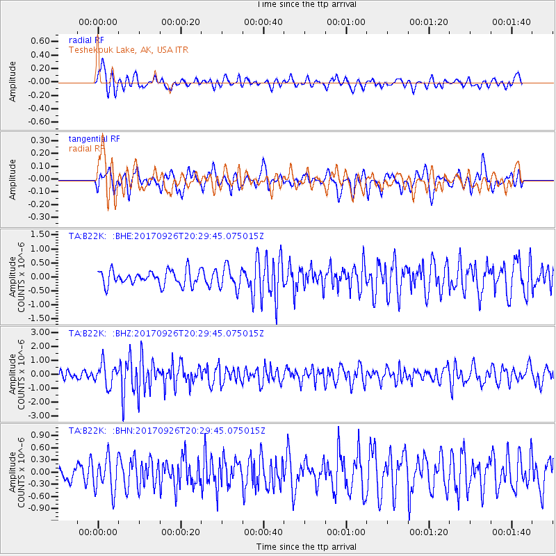
B22K Teshekpuk Lake, AK, USA - Earthquake Result Viewer
*The percent match for this event was below the threshold and hence no stack was calculated.
| Earthquake location: |
Near East Coast Of Honshu, Japan |
| Earthquake latitude/longitude: |
40.3/142.4 |
| Earthquake time(UTC): |
2017/09/26 (269) 20:22:11 GMT |
| Earthquake Depth: |
36 km |
| Earthquake Magnitude: |
5.8 Mww |
| Earthquake Catalog/Contributor: |
NEIC PDE/us |
|
| Network: |
TA USArray Transportable Network (new EarthScope stations) |
| Station: |
B22K Teshekpuk Lake, AK, USA |
| Lat/Lon: |
70.34 N/153.42 W |
| Elevation: |
50 m |
|
| Distance: |
44.0 deg |
| Az: |
26.007 deg |
| Baz: |
262.118 deg |
| Ray Param: |
$rayparam |
*The percent match for this event was below the threshold and hence was not used in the summary stack. |
|
| Radial Match: |
66.95177 % |
| Radial Bump: |
400 |
| Transverse Match: |
64.05644 % |
| Transverse Bump: |
400 |
| SOD ConfigId: |
13570011 |
| Insert Time: |
2019-04-28 21:45:35.690 +0000 |
| GWidth: |
2.5 |
| Max Bumps: |
400 |
| Tol: |
0.001 |
|
Signal To Noise
| Channel | StoN | STA | LTA |
| TA:B22K: :BHZ:20170926T20:29:45.075015Z | 2.1727295 | 8.020459E-7 | 3.6914207E-7 |
| TA:B22K: :BHN:20170926T20:29:45.075015Z | 1.8885553 | 4.2898571E-7 | 2.271502E-7 |
| TA:B22K: :BHE:20170926T20:29:45.075015Z | 1.5460677 | 3.9444674E-7 | 2.5512904E-7 |
| Arrivals |
| Ps | |
| PpPs | |
| PsPs/PpSs | |


