You are here: Home > Network List > TA - USArray Transportable Network (new EarthScope stations) Stations List
> Station B20K Meade River, AK, USA > Earthquake Result Viewer
B20K Meade River, AK, USA - Earthquake Result Viewer
| Earthquake location: |
Near East Coast Of Honshu, Japan |
| Earthquake latitude/longitude: |
40.3/142.4 |
| Earthquake time(UTC): |
2017/09/26 (269) 20:22:11 GMT |
| Earthquake Depth: |
36 km |
| Earthquake Magnitude: |
5.8 Mww |
| Earthquake Catalog/Contributor: |
NEIC PDE/us |
|
| Network: |
TA USArray Transportable Network (new EarthScope stations) |
| Station: |
B20K Meade River, AK, USA |
| Lat/Lon: |
70.01 N/157.16 W |
| Elevation: |
75 m |
|
| Distance: |
42.7 deg |
| Az: |
26.177 deg |
| Baz: |
258.726 deg |
| Ray Param: |
0.07294635 |
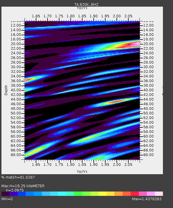
| Estimated Moho Depth: |
19.25 km |
| Estimated Crust Vp/Vs: |
2.10 |
| Assumed Crust Vp: |
6.048 km/s |
| Estimated Crust Vs: |
2.883 km/s |
| Estimated Crust Poisson's Ratio: |
0.35 |
|
| Radial Match: |
81.0267 % |
| Radial Bump: |
400 |
| Transverse Match: |
72.02202 % |
| Transverse Bump: |
400 |
| SOD ConfigId: |
13570011 |
| Insert Time: |
2019-04-28 21:45:35.646 +0000 |
| GWidth: |
2.5 |
| Max Bumps: |
400 |
| Tol: |
0.001 |
|

Signal To Noise
| Channel | StoN | STA | LTA |
| TA:B20K: :BHZ:20170926T20:29:34.500002Z | 4.16535 | 7.1666165E-7 | 1.7205318E-7 |
| TA:B20K: :BHN:20170926T20:29:34.500002Z | 0.965847 | 1.8248275E-7 | 1.8893546E-7 |
| TA:B20K: :BHE:20170926T20:29:34.500002Z | 2.1458359 | 3.499912E-7 | 1.631025E-7 |
| Arrivals |
| Ps | 3.7 SECOND |
| PpPs | 9.4 SECOND |
| PsPs/PpSs | 13 SECOND |


