You are here: Home > Network List > TA - USArray Transportable Network (new EarthScope stations) Stations List
> Station F14K Arctic Creek, AK, USA > Earthquake Result Viewer
F14K Arctic Creek, AK, USA - Earthquake Result Viewer

| Earthquake location: |
Near East Coast Of Honshu, Japan |
| Earthquake latitude/longitude: |
40.3/142.4 |
| Earthquake time(UTC): |
2017/09/26 (269) 20:22:11 GMT |
| Earthquake Depth: |
36 km |
| Earthquake Magnitude: |
5.8 Mww |
| Earthquake Catalog/Contributor: |
NEIC PDE/us |
|
| Network: |
TA USArray Transportable Network (new EarthScope stations) |
| Station: |
F14K Arctic Creek, AK, USA |
| Lat/Lon: |
65.47 N/166.33 W |
| Elevation: |
266 m |
|
| Distance: |
38.2 deg |
| Az: |
31.737 deg |
| Baz: |
254.473 deg |
| Ray Param: |
0.07560045 |
| Estimated Moho Depth: |
21.75 km |
| Estimated Crust Vp/Vs: |
2.10 |
| Assumed Crust Vp: |
6.307 km/s |
| Estimated Crust Vs: |
3.007 km/s |
| Estimated Crust Poisson's Ratio: |
0.35 |
|
| Radial Match: |
84.09672 % |
| Radial Bump: |
374 |
| Transverse Match: |
64.4512 % |
| Transverse Bump: |
400 |
| SOD ConfigId: |
13570011 |
| Insert Time: |
2019-04-28 21:45:59.888 +0000 |
| GWidth: |
2.5 |
| Max Bumps: |
400 |
| Tol: |
0.001 |
|
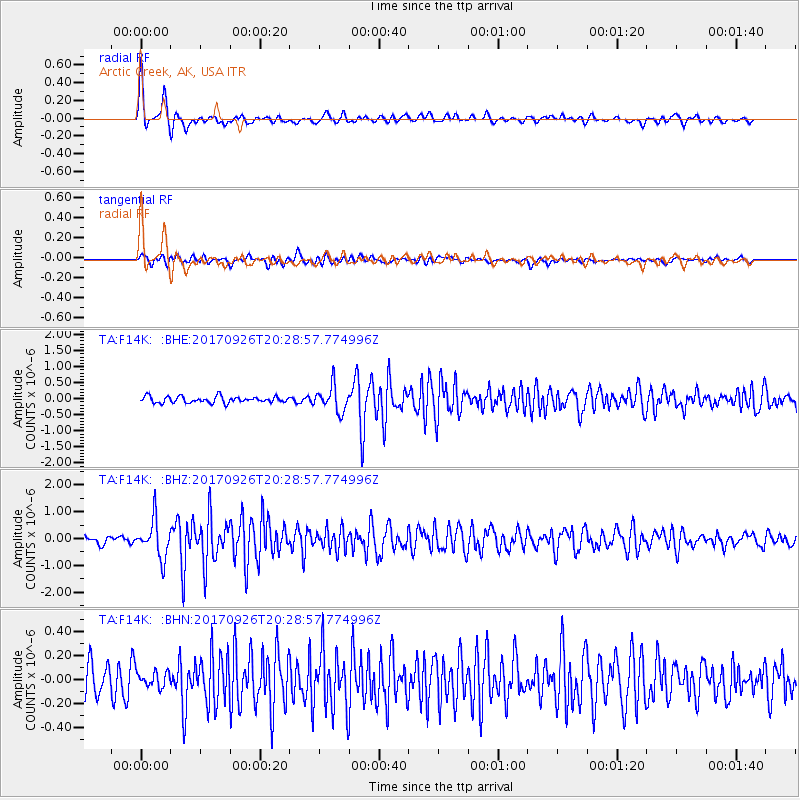
Signal To Noise
| Channel | StoN | STA | LTA |
| TA:F14K: :BHZ:20170926T20:28:57.774996Z | 5.442521 | 7.0342287E-7 | 1.2924576E-7 |
| TA:F14K: :BHN:20170926T20:28:57.774996Z | 0.57622635 | 6.489931E-8 | 1.1262815E-7 |
| TA:F14K: :BHE:20170926T20:28:57.774996Z | 4.0593276 | 3.9440016E-7 | 9.715899E-8 |
| Arrivals |
| Ps | 4.0 SECOND |
| PpPs | 10 SECOND |
| PsPs/PpSs | 14 SECOND |


