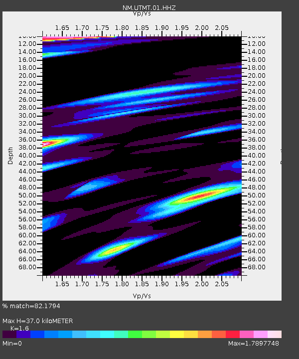
UTMT Martin, TN - Earthquake Result Viewer
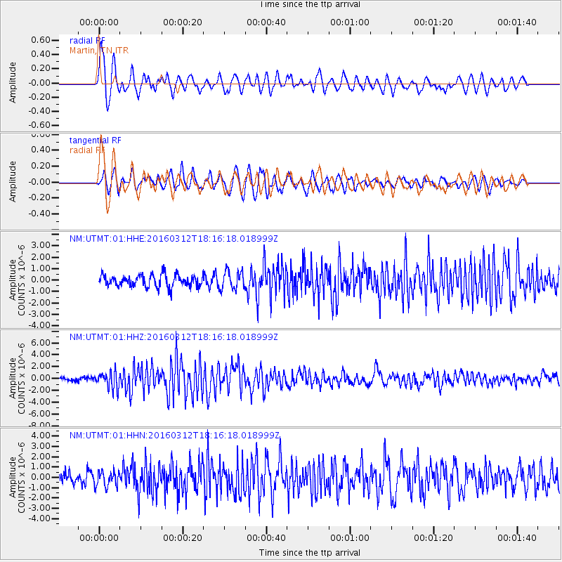
Earthquake location: Andreanof Islands, Aleutian Is.
Earthquake latitude/longitude: 51.6/-174.0
Earthquake time(UTC): 2016/03/12 (072) 18:06:45 GMT
Earthquake Depth: 19 km
Earthquake Magnitude: 6.3 MWW, 6.1 MB, 6.2 MWB, 6.3 MWC, 6.4 MWC, 6.4 MI
Earthquake Catalog/Contributor: NEIC PDE/NEIC COMCAT
Network: NM Cooperative New Madrid Seismic Network
Station: UTMT Martin, TN
Lat/Lon: 36.35 N/88.86 W
Elevation: 110 m
Distance: 59.8 deg
Az: 68.603 deg
Baz: 313.951 deg
Ray Param: 0.061951883
Estimated Moho Depth: 37.0 km
Estimated Crust Vp/Vs: 1.60
Assumed Crust Vp: 6.444 km/s
Estimated Crust Vs: 4.027 km/s
Estimated Crust Poisson's Ratio: 0.18
Radial Match: 82.1794 %
Radial Bump: 400
Transverse Match: 72.10033 %
Transverse Bump: 400
SOD ConfigId: 1453031
Insert Time: 2016-03-26 18:35:16.101 +0000
GWidth: 2.5
Max Bumps: 400
Tol: 0.001

Signal To Noise

ChannelStoNSTALTA
NM:UTMT:01:HHZ:20160312T18:16:18.018999Z4.6577521.4021167E-63.0102865E-7
NM:UTMT:01:HHN:20160312T18:16:18.018999Z1.6191497.369859E-74.5516867E-7
NM:UTMT:01:HHE:20160312T18:16:18.018999Z1.54020677.905345E-75.132652E-7
Arrivals
Ps3.6 SECOND
PpPs14 SECOND
PsPs/PpSs18 SECOND