You are here: Home > Network List > TA - USArray Transportable Network (new EarthScope stations) Stations List
> Station G21K Allakaket, AK, USA > Earthquake Result Viewer
G21K Allakaket, AK, USA - Earthquake Result Viewer
| Earthquake location: |
Near East Coast Of Honshu, Japan |
| Earthquake latitude/longitude: |
40.3/142.4 |
| Earthquake time(UTC): |
2017/09/26 (269) 20:22:11 GMT |
| Earthquake Depth: |
36 km |
| Earthquake Magnitude: |
5.8 Mww |
| Earthquake Catalog/Contributor: |
NEIC PDE/us |
|
| Network: |
TA USArray Transportable Network (new EarthScope stations) |
| Station: |
G21K Allakaket, AK, USA |
| Lat/Lon: |
66.52 N/153.51 W |
| Elevation: |
446 m |
|
| Distance: |
43.6 deg |
| Az: |
31.526 deg |
| Baz: |
266.024 deg |
| Ray Param: |
0.072381355 |
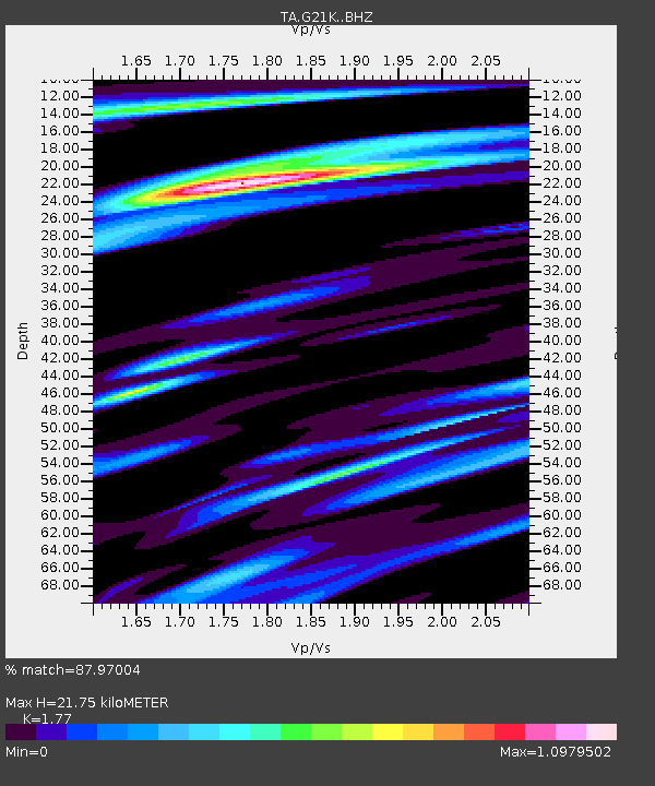
| Estimated Moho Depth: |
21.75 km |
| Estimated Crust Vp/Vs: |
1.77 |
| Assumed Crust Vp: |
6.455 km/s |
| Estimated Crust Vs: |
3.647 km/s |
| Estimated Crust Poisson's Ratio: |
0.27 |
|
| Radial Match: |
87.97004 % |
| Radial Bump: |
400 |
| Transverse Match: |
80.62056 % |
| Transverse Bump: |
400 |
| SOD ConfigId: |
13570011 |
| Insert Time: |
2019-04-28 21:46:15.237 +0000 |
| GWidth: |
2.5 |
| Max Bumps: |
400 |
| Tol: |
0.001 |
|
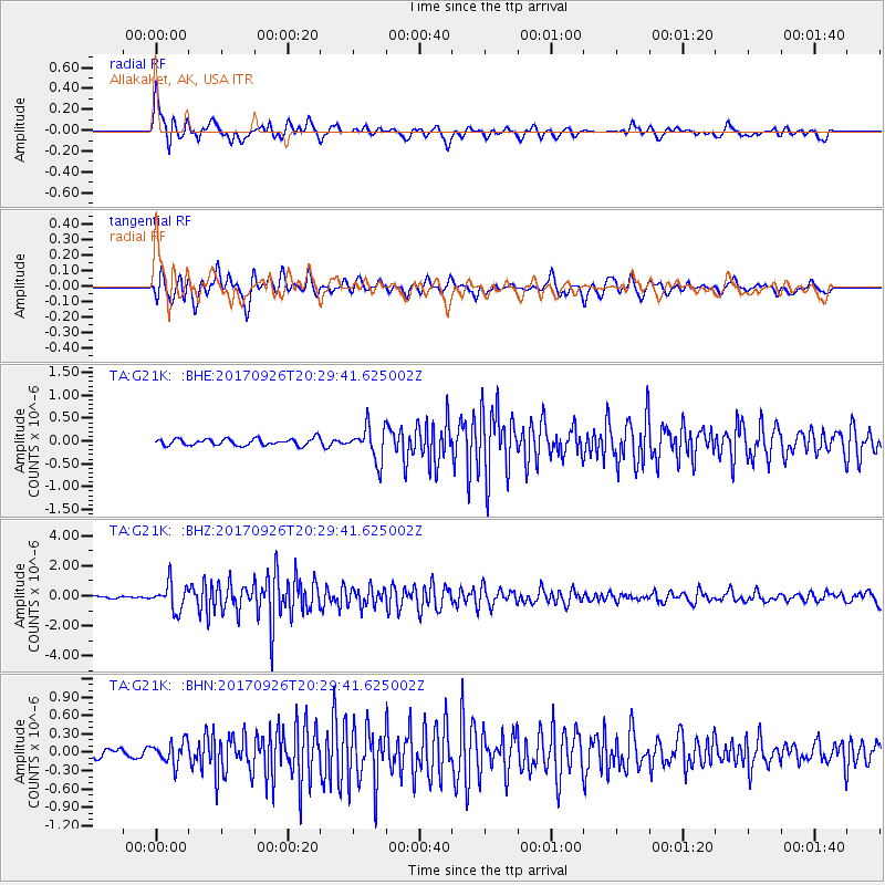
Signal To Noise
| Channel | StoN | STA | LTA |
| TA:G21K: :BHZ:20170926T20:29:41.625002Z | 12.999821 | 8.7415157E-7 | 6.7243356E-8 |
| TA:G21K: :BHN:20170926T20:29:41.625002Z | 1.6795853 | 1.8318602E-7 | 1.09066214E-7 |
| TA:G21K: :BHE:20170926T20:29:41.625002Z | 5.006946 | 3.6752724E-7 | 7.340348E-8 |
| Arrivals |
| Ps | 2.8 SECOND |
| PpPs | 8.7 SECOND |
| PsPs/PpSs | 12 SECOND |


