You are here: Home > Network List > TA - USArray Transportable Network (new EarthScope stations) Stations List
> Station G26K Porcupine River, AK, USA > Earthquake Result Viewer
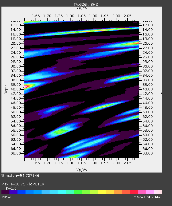
G26K Porcupine River, AK, USA - Earthquake Result Viewer
| Earthquake location: |
Near East Coast Of Honshu, Japan |
| Earthquake latitude/longitude: |
40.3/142.4 |
| Earthquake time(UTC): |
2017/09/26 (269) 20:22:11 GMT |
| Earthquake Depth: |
36 km |
| Earthquake Magnitude: |
5.8 Mww |
| Earthquake Catalog/Contributor: |
NEIC PDE/us |
|
| Network: |
TA USArray Transportable Network (new EarthScope stations) |
| Station: |
G26K Porcupine River, AK, USA |
| Lat/Lon: |
66.95 N/143.78 W |
| Elevation: |
180 m |
|
| Distance: |
47.4 deg |
| Az: |
30.892 deg |
| Baz: |
274.503 deg |
| Ray Param: |
0.06991465 |
| Estimated Moho Depth: |
38.75 km |
| Estimated Crust Vp/Vs: |
1.60 |
| Assumed Crust Vp: |
6.577 km/s |
| Estimated Crust Vs: |
4.11 km/s |
| Estimated Crust Poisson's Ratio: |
0.18 |
|
| Radial Match: |
94.707146 % |
| Radial Bump: |
400 |
| Transverse Match: |
92.76057 % |
| Transverse Bump: |
400 |
| SOD ConfigId: |
13570011 |
| Insert Time: |
2019-04-28 21:46:19.909 +0000 |
| GWidth: |
2.5 |
| Max Bumps: |
400 |
| Tol: |
0.001 |
|

Signal To Noise
| Channel | StoN | STA | LTA |
| TA:G26K: :BHZ:20170926T20:30:12.075015Z | 9.336549 | 7.9062886E-7 | 8.4681055E-8 |
| TA:G26K: :BHN:20170926T20:30:12.075015Z | 2.1288745 | 3.4576232E-7 | 1.6241555E-7 |
| TA:G26K: :BHE:20170926T20:30:12.075015Z | 4.5505466 | 4.7503835E-7 | 1.0439149E-7 |
| Arrivals |
| Ps | 3.8 SECOND |
| PpPs | 14 SECOND |
| PsPs/PpSs | 18 SECOND |


