You are here: Home > Network List > TA - USArray Transportable Network (new EarthScope stations) Stations List
> Station G31M Satah River, YT, CAN > Earthquake Result Viewer
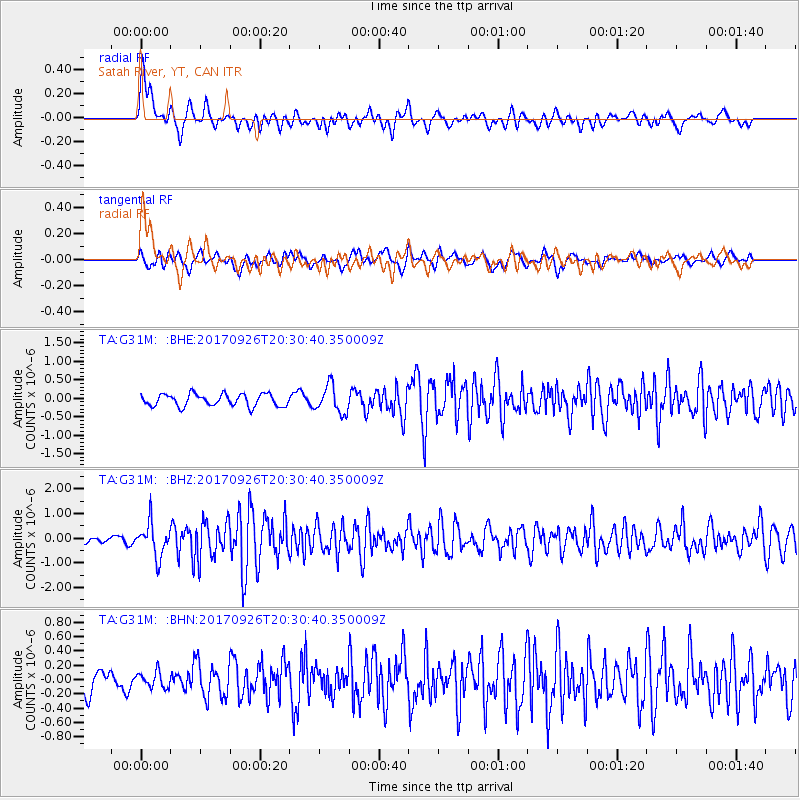
G31M Satah River, YT, CAN - Earthquake Result Viewer
*The percent match for this event was below the threshold and hence no stack was calculated.
| Earthquake location: |
Near East Coast Of Honshu, Japan |
| Earthquake latitude/longitude: |
40.3/142.4 |
| Earthquake time(UTC): |
2017/09/26 (269) 20:22:11 GMT |
| Earthquake Depth: |
36 km |
| Earthquake Magnitude: |
5.8 Mww |
| Earthquake Catalog/Contributor: |
NEIC PDE/us |
|
| Network: |
TA USArray Transportable Network (new EarthScope stations) |
| Station: |
G31M Satah River, YT, CAN |
| Lat/Lon: |
66.92 N/134.27 W |
| Elevation: |
61 m |
|
| Distance: |
51.1 deg |
| Az: |
30.185 deg |
| Baz: |
282.79 deg |
| Ray Param: |
$rayparam |
*The percent match for this event was below the threshold and hence was not used in the summary stack. |
|
| Radial Match: |
72.92077 % |
| Radial Bump: |
400 |
| Transverse Match: |
47.645733 % |
| Transverse Bump: |
400 |
| SOD ConfigId: |
13570011 |
| Insert Time: |
2019-04-28 21:46:22.392 +0000 |
| GWidth: |
2.5 |
| Max Bumps: |
400 |
| Tol: |
0.001 |
|
Signal To Noise
| Channel | StoN | STA | LTA |
| TA:G31M: :BHZ:20170926T20:30:40.350009Z | 5.0690713 | 6.6820144E-7 | 1.318193E-7 |
| TA:G31M: :BHN:20170926T20:30:40.350009Z | 0.69873214 | 1.09990665E-7 | 1.5741463E-7 |
| TA:G31M: :BHE:20170926T20:30:40.350009Z | 2.2749686 | 3.7016858E-7 | 1.627137E-7 |
| Arrivals |
| Ps | |
| PpPs | |
| PsPs/PpSs | |


