You are here: Home > Network List > TA - USArray Transportable Network (new EarthScope stations) Stations List
> Station P17K Kvichak River, AK, USA > Earthquake Result Viewer
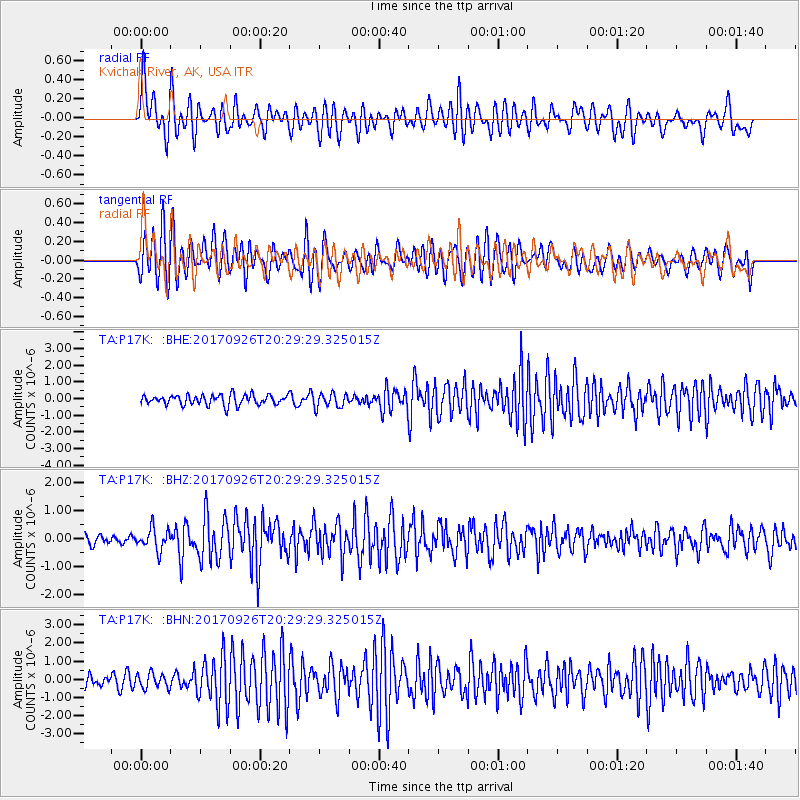
P17K Kvichak River, AK, USA - Earthquake Result Viewer
*The percent match for this event was below the threshold and hence no stack was calculated.
| Earthquake location: |
Near East Coast Of Honshu, Japan |
| Earthquake latitude/longitude: |
40.3/142.4 |
| Earthquake time(UTC): |
2017/09/26 (269) 20:22:11 GMT |
| Earthquake Depth: |
36 km |
| Earthquake Magnitude: |
5.8 Mww |
| Earthquake Catalog/Contributor: |
NEIC PDE/us |
|
| Network: |
TA USArray Transportable Network (new EarthScope stations) |
| Station: |
P17K Kvichak River, AK, USA |
| Lat/Lon: |
59.20 N/156.44 W |
| Elevation: |
91 m |
|
| Distance: |
42.1 deg |
| Az: |
42.295 deg |
| Baz: |
271.321 deg |
| Ray Param: |
$rayparam |
*The percent match for this event was below the threshold and hence was not used in the summary stack. |
|
| Radial Match: |
70.49599 % |
| Radial Bump: |
400 |
| Transverse Match: |
75.6604 % |
| Transverse Bump: |
400 |
| SOD ConfigId: |
13570011 |
| Insert Time: |
2019-04-28 21:47:29.566 +0000 |
| GWidth: |
2.5 |
| Max Bumps: |
400 |
| Tol: |
0.001 |
|
Signal To Noise
| Channel | StoN | STA | LTA |
| TA:P17K: :BHZ:20170926T20:29:29.325015Z | 2.238583 | 3.8238576E-7 | 1.7081598E-7 |
| TA:P17K: :BHN:20170926T20:29:29.325015Z | 1.2351173 | 4.0590334E-7 | 3.2863545E-7 |
| TA:P17K: :BHE:20170926T20:29:29.325015Z | 1.4073888 | 4.1899213E-7 | 2.9770885E-7 |
| Arrivals |
| Ps | |
| PpPs | |
| PsPs/PpSs | |


