You are here: Home > Network List > TA - USArray Transportable Network (new EarthScope stations) Stations List
> Station TUL3 Leonard, OK, USA > Earthquake Result Viewer
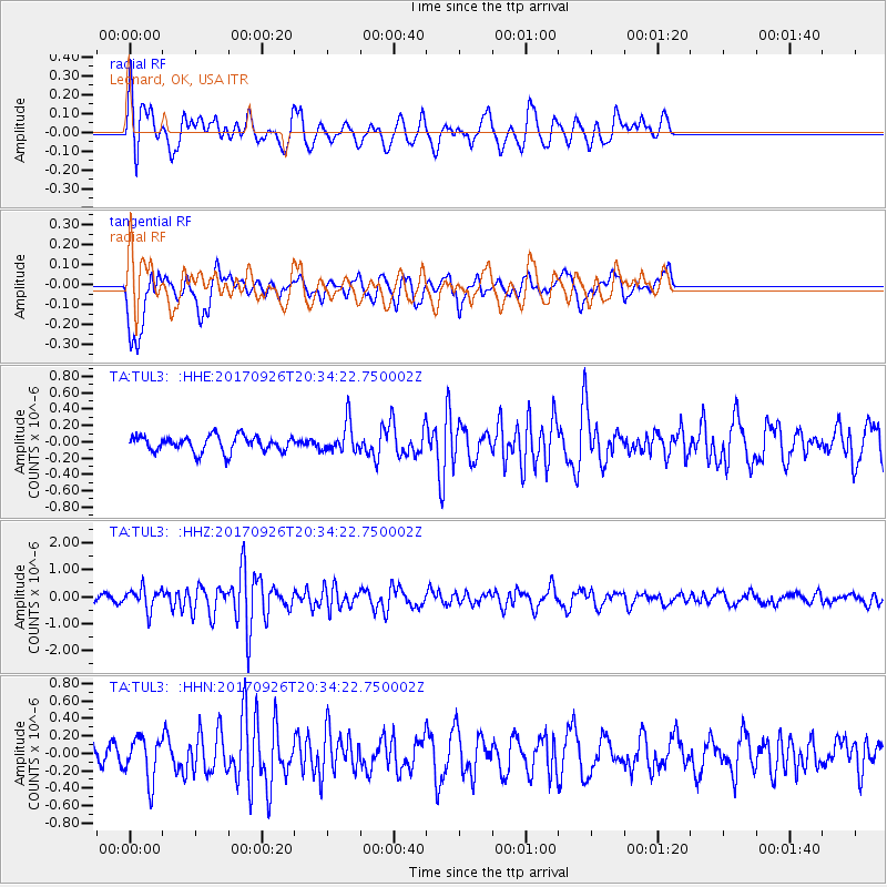
TUL3 Leonard, OK, USA - Earthquake Result Viewer
*The percent match for this event was below the threshold and hence no stack was calculated.
| Earthquake location: |
Near East Coast Of Honshu, Japan |
| Earthquake latitude/longitude: |
40.3/142.4 |
| Earthquake time(UTC): |
2017/09/26 (269) 20:22:11 GMT |
| Earthquake Depth: |
36 km |
| Earthquake Magnitude: |
5.8 Mww |
| Earthquake Catalog/Contributor: |
NEIC PDE/us |
|
| Network: |
TA USArray Transportable Network (new EarthScope stations) |
| Station: |
TUL3 Leonard, OK, USA |
| Lat/Lon: |
35.91 N/95.79 W |
| Elevation: |
265 m |
|
| Distance: |
87.2 deg |
| Az: |
43.691 deg |
| Baz: |
319.415 deg |
| Ray Param: |
$rayparam |
*The percent match for this event was below the threshold and hence was not used in the summary stack. |
|
| Radial Match: |
67.98695 % |
| Radial Bump: |
400 |
| Transverse Match: |
72.84963 % |
| Transverse Bump: |
400 |
| SOD ConfigId: |
13570011 |
| Insert Time: |
2019-04-28 21:47:44.106 +0000 |
| GWidth: |
2.5 |
| Max Bumps: |
400 |
| Tol: |
0.001 |
|
Signal To Noise
| Channel | StoN | STA | LTA |
| TA:TUL3: :HHZ:20170926T20:34:22.750002Z | 3.5500205 | 4.0273358E-7 | 1.13445424E-7 |
| TA:TUL3: :HHN:20170926T20:34:22.750002Z | 1.9282178 | 2.4559463E-7 | 1.2736872E-7 |
| TA:TUL3: :HHE:20170926T20:34:22.750002Z | 1.9419072 | 1.8630627E-7 | 9.593984E-8 |
| Arrivals |
| Ps | |
| PpPs | |
| PsPs/PpSs | |


