You are here: Home > Network List > CI - Caltech Regional Seismic Network Stations List
> Station SMM Simmler, CA, USA > Earthquake Result Viewer
SMM Simmler, CA, USA - Earthquake Result Viewer
| Earthquake location: |
Nicaragua |
| Earthquake latitude/longitude: |
11.2/-85.5 |
| Earthquake time(UTC): |
2005/08/03 (215) 11:03:15 GMT |
| Earthquake Depth: |
14 km |
| Earthquake Magnitude: |
6.0 MB, 6.5 MS, 6.3 MW, 6.3 MW |
| Earthquake Catalog/Contributor: |
WHDF/NEIC |
|
| Network: |
CI Caltech Regional Seismic Network |
| Station: |
SMM Simmler, CA, USA |
| Lat/Lon: |
35.31 N/120.00 W |
| Elevation: |
599 m |
|
| Distance: |
39.4 deg |
| Az: |
313.16 deg |
| Baz: |
118.952 deg |
| Ray Param: |
0.0750145 |
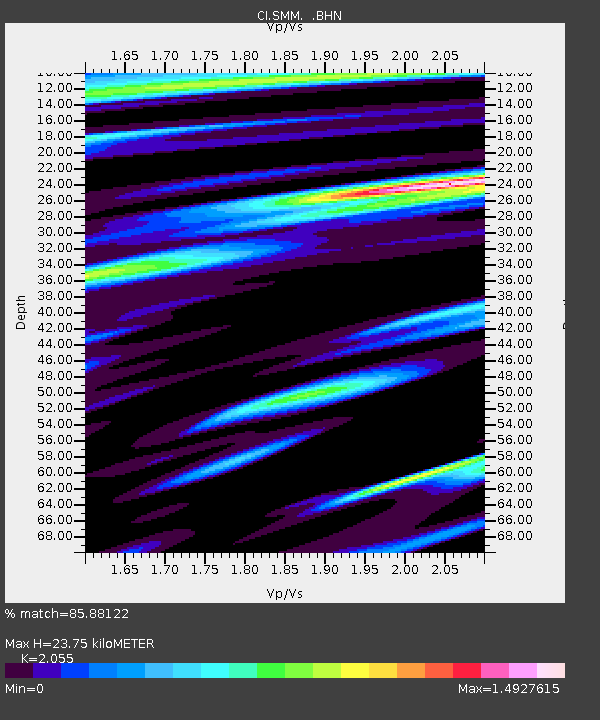
| Estimated Moho Depth: |
23.75 km |
| Estimated Crust Vp/Vs: |
2.06 |
| Assumed Crust Vp: |
6.1 km/s |
| Estimated Crust Vs: |
2.968 km/s |
| Estimated Crust Poisson's Ratio: |
0.34 |
|
| Radial Match: |
85.88122 % |
| Radial Bump: |
400 |
| Transverse Match: |
58.031548 % |
| Transverse Bump: |
400 |
| SOD ConfigId: |
2475 |
| Insert Time: |
2010-02-26 01:30:00.308 +0000 |
| GWidth: |
2.5 |
| Max Bumps: |
400 |
| Tol: |
0.001 |
|
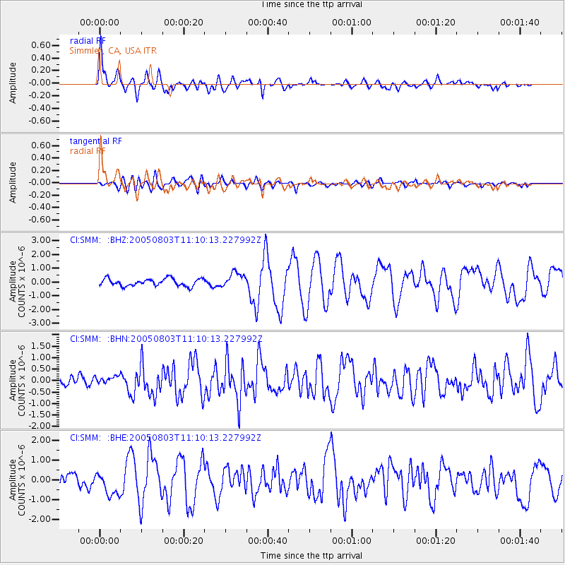
Signal To Noise
| Channel | StoN | STA | LTA |
| CI:SMM: :BHN:20050803T11:10:13.227992Z | 0.83486414 | 1.7255473E-7 | 2.06686E-7 |
| CI:SMM: :BHE:20050803T11:10:13.227992Z | 2.445582 | 6.148165E-7 | 2.5139883E-7 |
| CI:SMM: :BHZ:20050803T11:10:13.227992Z | 2.111751 | 5.5223063E-7 | 2.6150366E-7 |
| Arrivals |
| Ps | 4.3 SECOND |
| PpPs | 11 SECOND |
| PsPs/PpSs | 16 SECOND |


